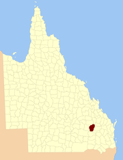
County of Fortescue
The County of Fortescue is a county (a cadastral division) in Central Queensland, Queensland, Australia. Much of its area is within the Barakula State Forest. It was named and bounded by the Governor in Council on 7 March 1901 under the Land Act 1897.[1][2]
| Fortescue Queensland | |||||||||||||||
|---|---|---|---|---|---|---|---|---|---|---|---|---|---|---|---|
 Location within Queensland | |||||||||||||||
| |||||||||||||||
Parishes
Fortescue is divided into parishes, as listed below:
| Parish | LGA | Coordinates | Towns |
|---|---|---|---|
| Ardah | Banana | 25°51′S 149°39′E | |
| Bentley | Banana | 25°42′S 150°02′E | |
| Biloela | Banana | 25°46′S 150°10′E | |
| Bockemurry | Banana | 25°46′S 150°20′E | |
| Bundi | Western Downs | 25°58′S 149°40′E | |
| Bungaban | Western Downs | 25°57′S 150°09′E | |
| Carraba | Banana | 25°47′S 149°45′E | |
| Cherwondah | Western Downs | 26°15′S 150°00′E | Guluguba |
| Cockatoo | Banana | 25°37′S 150°02′E | |
| Conloi | Western Downs | 26°20′S 149°55′E | |
| Cooaga | Western Downs | 26°06′S 150°15′E | |
| Dawson | Banana | 25°33′S 150°20′E | |
| Downfall | Western Downs | 26°14′S 150°07′E | |
| Glebe | Banana | 25°32′S 150°02′E | |
| Hinchley | Western Downs | 26°08′S 149°44′E | |
| Jerrard | Western Downs | 26°02′S 150°04′E | |
| Juandah | Western Downs | 26°08′S 149°50′E | |
| Juliet | Western Downs | 25°52′S 150°02′E | |
| Kera | Banana | 25°44′S 149°54′E | |
| Kroomgah | Banana | 25°40′S 150°18′E | |
| Langhorne | Western Downs | 25°51′S 149°54′E | |
| McLeod | Banana | 25°35′S 150°12′E | |
| Mundell | Western Downs | 25°56′S 150°17′E | |
| Price | Banana | 25°28′S 150°12′E | |
| Rochedale | Western Downs | 25°58′S 149°50′E | Grosmont |
| Taroom | Banana | 25°38′S 149°51′E | Taroom |
| Wandoan | Western Downs | 26°08′S 150°00′E | Wandoan |
| Woleebee | Maranoa | 26°18′S 149°45′E |
gollark: Some currencies do proof of stake instead.
gollark: Something like that?
gollark: There's this neat somewhat experimental proof of work thing, no idea if any cryptocurrencies *use* it: https://github.com/tromp/cuckoo
gollark: There are other cryptocurrencies using different proof of work things.
gollark: I think theoretically stuff could be switched over to a non-SHA256 algorithm, requiring... either the majority of mining power to agree to it or I guess just a lot of the nodes.
References
- "Fortescue (entry 12934)". Queensland Place Names. Queensland Government. Retrieved 8 September 2015.
- Leichhardt District, County of Fortescue Maps – H2 Series at Queensland Archives.
External links
This article is issued from Wikipedia. The text is licensed under Creative Commons - Attribution - Sharealike. Additional terms may apply for the media files.