County of Boondooma
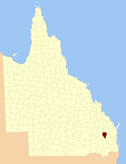
The County of Boondooma is a county (a cadastral division) in the Wide Bay–Burnett region of Queensland, Australia. It was named and bounded by the Governor in Council on 7 March 1901 under the Land Act 1897.[1][2]
| Boondooma Queensland | |||||||||||||||
|---|---|---|---|---|---|---|---|---|---|---|---|---|---|---|---|
 Location within Queensland | |||||||||||||||
| |||||||||||||||
Parishes
Boondooma is divided into parishes, as listed below:
| Parish | LGA | Coordinates | Towns |
|---|---|---|---|
| Ballogie | South Burnett | 26°19′S 151°35′E | |
| Boondooma | South Burnett | 26°14′S 151°09′E | Boondooma |
| Burrandowan | South Burnett | 26°40′S 151°30′E | |
| Chahpingah | South Burnett | 26°29′S 151°19′E | Durong |
| Cushnie | South Burnett | 26°17′S 151°43′E | |
| Dangore | South Burnett | 26°28′S 151°35′E | |
| Durong | South Burnett | 26°20′S 151°12′E | |
| Jua | South Burnett | 26°19′S 151°23′E | |
| Lawson | South Burnett | 26°13′S 151°23′E | |
| Mannuem | South Burnett | 26°25′S 151°28′E | |
| Okeden | South Burnett | 26°06′S 151°30′E | |
| Peroone | South Burnett | 26°24′S 151°26′E | |
| Proston | South Burnett | 26°11′S 151°34′E | Proston |
| Waringa | South Burnett | 26°06′S 151°21′E | |
| Weir Weir | South Burnett | 26°04′S 151°11′E |
gollark: I moved the program generator to a dedicated machine instead of terrariola's main computer.
gollark: At current progress rates, an AI which will destroy switchcraft will be released within the week.
gollark: `w = 7`How wonderful.
gollark: Ooh, one produced a runtime error!
gollark: The code is mostly just```[nonexistent variable name]=[nonexistent variable name]```
References
- "Boondooma (entry 3753)". Queensland Place Names. Queensland Government. Retrieved 4 June 2013.
- Wide Bay/Burnett Districts, County of Boondooma Maps – D1 Series at Queensland Archives.
External links
This article is issued from Wikipedia. The text is licensed under Creative Commons - Attribution - Sharealike. Additional terms may apply for the media files.