Cosford Rural District
Cosford Rural District was a rural district in the county of West Suffolk, England. It was created in 1894 out of the earlier Cosford rural sanitary district, except for Hadleigh parish which was made a separate urban district. Only minor adjustments were made to its boundary in the reorganisation of 1935.[1]
| Cosford | |
|---|---|
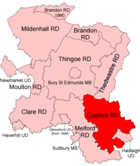 Location within West Suffolk, 1894 | |
| History | |
| • Created | 1894 |
| • Abolished | 1974 |
| • Succeeded by | Babergh |
| Status | Rural district |
Since 1 April 1974 it has formed part of the local government district of Babergh.
Parishes
Cosford RD contained the parishes of Aldham, Bildeston, Boxford, Brent Eleigh, Brettenham, Chelsworth, Cockfield, Edwardstone, Elmsett, Groton, Hadleigh Hamlet (abolished 1935), Hitcham, Kersey, Kettlebaston, Lavenham, Layham, Lindsey, Milden, Monks Eleigh, Nedging with Naughton (2 parishes before 1935), Polstead, Preston St Mary, Semer, Thorpe Morieux, Wattisham and Whatfield.
Statistics
| Year | Area[2] | Population [3] |
Density (pop/ha) | |
|---|---|---|---|---|
| acres | ha | |||
| 1911 | 48,573 | 19,657 | 11,808 | 0.60 |
| 1921 | 10,392 | 0.53 | ||
| 1931 | 9,551 | 0.49 | ||
| 1951 | 48,530 | 19,640 | 9,536 | 0.49 |
| 1961 | 48,529 | 19,639 | 9,068 | 0.46 |
References
- "Cosford RD through time: Census tables with data for the Local Government District". A Vision of Britain through Time. GB Historical GIS / University of Portsmouth. Retrieved 8 July 2017.
- "Cosford RD through time: Population Statistics: Area (acres)". A Vision of Britain through Time. GB Historical GIS / University of Portsmouth. Retrieved 8 July 2017.
- "Cosford RD through time: Population Statistics: Total Population". A Vision of Britain through Time. GB Historical GIS / University of Portsmouth. Retrieved 8 July 2017.