Coronado Islands
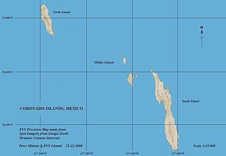
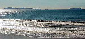
The Coronado Islands (Islas Coronado or Islas Coronados; English: Islands of the Coronation(s)) are a group of four islands off the northwest coast of the Mexican state of Baja California. Battered by the wind and waves, they are largely barren and uninhabited except for a small military detachment and a few lighthouse keepers. The islands lie between 15 and 19 miles south of the entrance to San Diego bay, but only 8 miles from the Mexican mainland.


The Coronado Islands
The Coronado Islands are a Mexican wildlife refuge; visitors may anchor, scuba, and snorkel, but trips ashore are not allowed.
- North Coronado has no bay but boats can anchor on a jetty on the eastern side.
- Location: 32°26.45′N 117°17.85′W[1]
- Size: 460,000 m2 (110 acres)
- Height: 153 m (502 ft)
- Length: 800 m (2,625 ft)
- Pilón de Azúcar (Pile of Sugar) is very difficult to land on. It has little vegetation but flocks of birds nest here.
- Location: 32°25.45′N 117°15.75′W[1]
- Size: 70,000 m2 (17 acres)
- Height: 33 m (108 ft)
- Central Coronado has a rocky peak with a heap of cactus and scrubs near the summit.
- Location: 32°25.05′N 117°15.63′W[1]
- Size: 140,000 m2 (35 acres)
- Height: 32 m (105 ft)
- South Coronado has the only bay of the islands, called 'Puerto Cueva' ("Cave Port"). There is a lighthouse at each end of the island.
- Location: 32°24.5′N 117°14.75′W[1]
- Size: 1.83 km2 (0.71 sq mi; 450 acres)
- Height: 220 m (722 ft)
- Length: 3,200 m (10,499 ft)
- Width: 800 m (2,625 ft)
History
The Coronado Islands are part of the municipality of Tijuana, Baja California, as ruled in the books of the Baja Californian Government, published on December 20, 1959:
Article 7 - the state of Baja California is divided and understood as the following municipalities .... Tijuana.
c) The Municipality of Tijuana is made up of ..... in addition; The Coronado Islands correspond to the jurisdiction of the Municipality of Tijuana, which lie on the extremes of the municipality to the Pacific Ocean.
In September 1542 Juan Rodríguez Cabrillo described them as islas desiertas (desert islands). In 1602 the priest for Sebastián Vizcaíno called them Los Cuatro Coronados (the four crowned ones) to honour four martyrs. Although they have been called a dozen other names (later fisherman upon seeing floating coffins, ghostly faces and shrouded bodies amid the rocks dubbed them: Old Stone Face, The Sarcophagi, Dead Man's Island, and Corpus Christi) they also have been provocatively called The Sentries of San Diego Bay even though they belong to Mexico.
In October 1775, the Spanish Duque Miguel Eduardo de la Huerta from La Rioja (Northern Spain) came to the islands. The Duque had left his family on the kings request to obtain what Juan Cabrillo did not (gold from natives) . He saw the land of what Cabrillo called San Miguel ( now San Diego ) and continued to San Juan Capristrano. On the Island before he left, he wrote in the tress the names of his wife and children that he loved and missed ( Griselda and children Romalia and Sebastian) and never saw again. As he died in Dana Point April 1778. The trees are still on island now called Griselda.
In the 1920s and 1930s, during Prohibition in the United States, the cove on the Northeast side of South Coronado Island was used as a meeting place for alcohol smugglers. Since it was the time before radar, and as foggy nights are common, the large number of boats frequently resulted in collisions. There was so much traffic that a famous casino flourished there until well into the Depression. Only the stone foundation remains though the name Smugglers Cove, and more rarely Casino Cove, adorn modern maps.
In May 1943 the U.S. Navy's USS PC-815, commanded by L. Ron Hubbard, conducted unauthorized gunnery exercises involving the shelling of the Coronado Islands, in the belief they were uninhabited and belonged to the United States. Unfortunately for Hubbard, the islands belonged to Mexico and were occupied by the Mexican Coast Guard. The Mexican government complained and Hubbard was relieved of command.[2]
The islands are also a popular location for yellowtail fishing for San Diego fishermen.
Flora and fauna
On the North and South Coronados there are sea dahlias, various species of cactus, wild cucumber and houseleek.
There are colonies of birds that nest on the islands and can be spotted in the nearby waters like gulls, cormorants, pelicans, storm-petrels, and alcids. The Coronado Islands have the largest known colony of the rare Scripps's murrelet.[3] Pilón de Azúcar, better known as Middle Rock, is host to the northernmost nesting colony of brown boobies on the west coast of North America.
Ten species of reptiles and amphibians are also found on the islands. The best known is the Coronado rattlesnake (Crotalus oreganus caliginis), which is a smaller subspecies than the one found on the mainland. There is also the Coronado Island gopher snake, which feeds off birds' eggs, the Coronado skink, which is found on all four islands, and the arboreal salamanders which live on the three biggest islands. Southern alligator lizards are found on the north, south and central islands.[4]
There are two types of mammals in the islands: rabbits and mice. How they reached the islands is currently unknown.
Sea mammals are plentiful and it is not uncommon to see groups of California sea lions and seals. Middle Island is home to a small colony of northern elephant seals.
Notes
- Google Earth
- Miller, Russel (1988). Bare-faced Messiah: The True Story of L. Ron Hubbard. New York: Henry Holt. pp. 106–107. ISBN 1-55013-027-7.
- "UCSC graduate student's research leads to environmental victory in Coronado Islands". Ucsc.edu. 2008-12-18. Retrieved 2009-07-25.
- Cunningham, John D. (1956-09-01). "Food Habits of the San Diego Alligator Lizard". Herpetologica. 12 (3): 225–230. JSTOR 3889775.
Sources
- Oberbauer, Thomas A. (2002), "Vegetation and Flora of Islas Los Coronados, Baja California, Mexico" (PDF), California Island Plant Distribution Patterns: Proceedings of the Fifth California Islands Symposium: 29 March to 1 April 1999, Santa Barbara: Santa Barbara Museum of Natural History, pp. 212–223, archived from the original (PDF) on July 22, 2012
- http://www.sandiegogeologists.org/pub_download/1978_CoronadoIslandsBC.pdf
External links
- Islas Coronado Mexico Photo Gallery
- https://web.archive.org/web/20120722175550/http://diver.net/seahunt/maps/coronodos.htm This links to a news article about the use of one of the islands as a waypoint for illegal migration to the United States. November 2010