Corn Belt derecho
The Corn Belt derecho was a progressive derecho which affected a large area of the central United States on June 29, 1998. In the morning, thunderstorms, including a supercell, developed over South Dakota and tracked into central Iowa. As the thunderstorms reached central Iowa, a strong rear-inflow jet developed which caused the thunderstorm to take on a different characteristic, becoming a derecho. It traveled more than 600 miles in about ten hours, causing more than $125 million worth of widespread damage destruction, especially to crops, and was responsible for power outages to nearly a half a million people.[1]
 | |
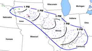
| Path of the Corn Belt Derecho. | |
| Date(s) | June 29, 1998 |
|---|---|
| Duration | ~10 hours (12:00 PM-10:00 PM) |
| Track length | ≈600 Miles |
| Peak wind gust | 123 mph (Washington, Iowa) |
| Largest hail | 2.5 inches (Des Moines, Iowa) |
| Tornadoes caused | 20 (Crawford County, Iowa) |
| Maximum rated tornado1 | F2 tornado |
| Fatalities | None (at least 85 injured) |
| Damage Costs | $125 million |
| Areas affected | Midwestern United States |
| 1Most severe tornado damage; see Fujita scale | |
Meteorological synopsis

At 1200 UTC (7:00 am. CDT), a stationary front extended from South Dakota to Southern Michigan, bringing warm and humid to its South. Temperature was around 25 °C (77 °F) at this early hour and the dew point was at 23 °C (73 °F). At 850 mb, the southwesterly flow was maintaining this situation while at higher levels the flow was turning to the northwest, bringing drier and colder air. Daytime heating would increase the instability of the airmass and the CAPE was expected to reach a strong 3689 J/kg.[2] At the same time, there was relatively weak synoptic-scale forcing, the surface flow being a barometric col.[3]
Along the front in South Dakota, an unorganized area of thunderstorms formed by 9:00 a.m. CDT. They rapidly organized and spread along the front, moving east-southeast into northeast Nebraska.[3] By midday, the storms reached northwestern and north central Iowa, supercells among them, while forming an west–east band and assuming a bow echo shape.[1][3]
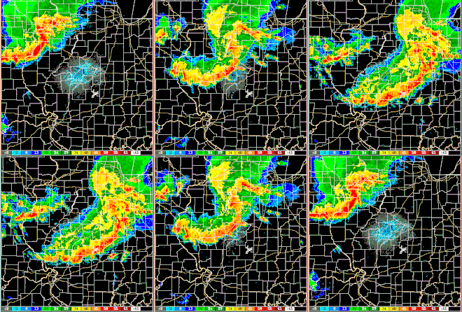
In the early afternoon, a second area of thunderstorms formed west of Des Moines and merged with the original bow echo line which accelerating east-southeast into Illinois by 4:00 p.m. The line evolved into a classic large scale bow echo, showing a "book end vortex" on its northern end,[1] becoming a progressive derecho.[2] Damage, especially to crops and trees, became continuous from the Iowa border into Indiana as most of the damage was produced by strong straight-line winds on the leading edge of the gust front. Some embedded supercells, showing smaller-scale vortices on radars, produced narrower corridors of more intense damage, with measured wind gusts up to at least 110 miles per hour (180 km/h).[1][2]
The derecho crossed central and southern Indiana during the early to mid evening while its highest wind gusts decreased somewhat compared with those observed earlier in the day. The system became a roughly west–east arc and turned more southward as it moved into Kentucky by late evening, dissipating gradually[1]
Impact

By the end of the morning, the thunderstorms produced hail up to the size of hen's eggs and locally damaging wind in Nebraska. By mid-day, supercells along the bow echo in Iowa began to produce very strong winds, up to tennis ball-sized hail, and several mostly short-lived tornadoes.[1] On Doppler weather radar, a large fast-moving mesocyclone associated of the track of a supercell was nearly in contact with the ground as it moved from southwest Boone County east-southeast across the northern and eastern parts of the Des Moines metro area.[1]
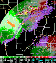
Over the Davenport, Iowa NWS Weather Office area of responsibility, numerous reports of wind gusts ranging from 80 to 100 mph were received. The highest measured wind gust of 123 mph (198 km/h) was reported in Washington, Iowa near coordinates 41.3°N 91.7°W. This is the highest unofficial recorded wind gust in the history of the state of Iowa.[4] At the same moment, the area of green in the radar display to the right shows the velocities toward the weather radar. The lighter shade, beneath the orange arrow, represented Doppler-estimated mean wind speeds in excess of 64 knots (119 km/h) all along the gust front, and the yellow circle are mesocyclone detections.
In Illinois, railroad cars were toppled, steel power transmission towers were bent, and many buildings were seriously damaged during the afternoon.[1] By the evening into Indiana, hundreds of trees were uprooted in the Bedford and Indianapolis areas, two semi-trailer trucks were blown off Interstate 65 near Columbus.[1] By late evening, damage into Kentucky was minimal, mostly limited to toppled trees and several blown off roofs.[1]
Along with the long-lived derecho, 20 tornadoes were reported, one of which was an F2 tornado, injuring 85 people in central Iowa. Over eight states, the derecho and associated tornadoes killed one person and injured 174.[5][6]
See also
References
- Corfidi, Stephen. "The "Corn Belt Derecho" of June 1998". NOAA. Retrieved November 30, 2018.
- Arnott, Justin M.; Atkins, N. T. (August 15, 2002). Tornadogenesis within quasi-linear convective systems. Part I: Radar and storm damage analysis of the 29 June 1998 derecho (PDF). 21st Conf. on Severe Local Storms. San Antonio, TX: AMS. p. 13.4.
- Arnott, Justin M.; Atkins, N. T.; Rzybylinski, Ron W. P; Wolf, Ray A.; Ketcham, Bradley D. (September 2004). "Vortex Structure and Evolution within Bow Echoes. Part I: Single-Doppler and Damage Analysis of the 29 June 1998 Derecho". Monthly Weather Review. 132 (9): 2224–2242. doi:10.1175/1520-0493(2004)132<2224:VSAEWB>2.0.CO;2. S2CID 32372437.
- NWS Quad Cities IA/IL Weather Forecast Office. "June 29, 1998 Derecho". US National Weather Service. Retrieved November 30, 2018.
- Data from the Storm Prediction Center archives, which are accessible through SeverePlot, free software created and maintained by John Hart, lead forecaster for the SPC.
- "Tornadoes on June 29, 1998". TornadoHistoryProject.com. Retrieved December 3, 2018.
- Ashley, Walker S.; T.L. Mote; M.L. Bentley (Sep 2007). "The extensive episode of derecho-producing convective systems in the United States during May and June 1998: A multi-scale analysis and review". Meteorol. Appl. 14 (3): 227–44. Bibcode:2007MeApp..14..227A. doi:10.1002/met.23.
External links
- Storm Prediction Center's 'About Derechos' web page summary of the event by Stephen Corfidi
- NWS Quad Cities overview
Copy from the above referenced website.