Comoros forests
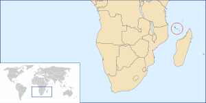
The Comoros forests is a terrestrial ecoregion which covers the Comoro Islands. The Comoro Islands lie in the Mozambique Channel between Madagascar and East Africa. There are four main islands – Grande Comore, Anjouan, Mohéli, and Mayotte – and several smaller ones. The islands are politically divided between two countries; the Union of the Comoros is an independent nation that includes three of the main islands, while Mayotte is a region of France.
| Comoros forests | |
|---|---|
 Location of the Comoros Islands | |
| Ecology | |
| Realm | Afrotropical |
| Biome | Tropical and subtropical moist broadleaf forests |
| Geography | |
| Area | 2,100 km2 (810 sq mi) |
| Countries | Comoros and Mayotte (an overseas region of France) |
| Conservation | |
| Conservation status | Critical/Endangered[1] |
These volcanic islands are rich in wildlife with endemic species including four endangered bird species living on Mount Karthala, the large active volcano on Grande Comore. The islands have a wet tropical climate with a rainy season between October and April.[2]
Flora
Both the flora and the fauna are similar to Madagascar, although there are more than 500 species of plants endemic to the Comoros. The two larger islands Grande Comore and Anjouan have higher peaks and a variety of lowland and mountain forest, with mangroves along the coasts.
Fauna
There are more birds, mammals, and reptiles than one would expect to find on an Indian Ocean island, including lemurs, as in nearby Madagascar. Endemic species include 21 species of birds, 9 species of reptiles, and two species of fruit bats (Pteropus livingstonii and Rousettus obliviosus). Other mammals include the mongoose lemur (Eulemur mongoz) and a sub-species of the Seychelles fruit bat (Pteropus seychellensis comorensis).
Threats and conservation
The population of the Comoros is currently over 700,000 and as it increases more and more forest is being cleared for farming, with volcanic eruptions and cyclones damaging the forest further, and threatening the fruit bat populations in particular.
The largest unspoilt forest remaining is located on the higher mountain slopes including Mount Karthala, which is unprotected as is the forest on Ntingui on Anjouan. Protected areas include Mount Combani and the Saziley National Park on Mayotte, while the only protected area in Comoros proper is the marine park on Moheli.
Visiting the ecoregion
Grande Comore, dominated by Mount Karthala, which can be climbed in one or two days, is the largest and most developed island and location of the international airport. Anjouan is reached by boat from Grande Comore, the two features here are Mount Ntingui and Lake Dzialandzé, both Ramsar List sites. Saziley Point is visited from the village of Dapani on Mayotte, there is a birding trail through the forest. Moheli is the smallest and quietest island and the marine park, home to sea turtles, dolphins and whales, is located on five offshore islets.
See also
Category:Biota of Comoros
References
- "Comoros forests". World Wildife Fund. Accessed 8 April 2020.
- World Wildlife Fund, ed. (2001). "Comoros forests". WildWorld Ecoregion Profile. National Geographic Society. Archived from the original on 2010-03-08.
External links
- "Comoros forests". Terrestrial Ecoregions. World Wildlife Fund.
- Annotated Ramsar List entry for Comoros
- https://web.archive.org/web/20100616062500/http://africanbirdclub.org/countries/Comores/ibas.html