Columbus Near East Side District
The Columbus Near East Side District is a historic district in the Near East Side of Columbus, Ohio. The site was listed on the National Register of Historic Places in 1978. A portion of the district, the Bryden Road District, was added to the Columbus Register of Historic Properties in 1990.[1][2][3]
Columbus Near East Side District | |
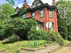 Contributing building | |

Interactive map | |
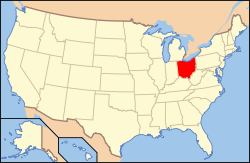
| Location | Columbus, Ohio |
|---|---|
| Coordinates | 39.963119°N 82.966207°W |
| NRHP reference No. | 78002063[1] (original) 83004287 (increase) |
| CRHP No. | CR-44 |
| Significant dates | |
| Added to NRHP | May 19, 1978 |
| Boundary increase | December 9, 1983 |
| Designated CRHP | March 20, 1990 |
Columbus Public Health, Franklin Park, and the Franklin Park Conservatory all lie within the National Register district.[2]
References
- "National Register Information System". National Register of Historic Places. National Park Service. March 13, 2009.
- "National Register of Historic Places Registration Form". National Park Service. Retrieved June 25, 2020.
- "National Register of Historic Places Registration Form - boundary addition". National Park Service. Retrieved June 25, 2020.
External links

This article is issued from Wikipedia. The text is licensed under Creative Commons - Attribution - Sharealike. Additional terms may apply for the media files.