National Register of Historic Places listings in Crawford County, Ohio
This is a list of the National Register of Historic Places listings in Crawford County, Ohio.
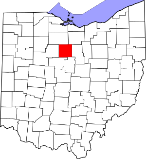
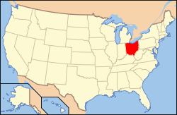
Location of Crawford County in Ohio
This is intended to be a complete list of the properties and districts on the National Register of Historic Places in Crawford County, Ohio, United States. The locations of National Register properties and districts for which the latitude and longitude coordinates are included below, may be seen in a Google map.[1]
There are 26 properties and districts listed on the National Register in the county. Another property was once listed but has been removed.
- This National Park Service list is complete through NPS recent listings posted August 14, 2020.[2]
Current listings
| [3] | Name on the Register[4] | Image | Date listed[5] | Location | City or town | Description |
|---|---|---|---|---|---|---|
| 1 | Judge Thomas Beer House | 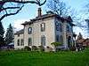 Judge Thomas Beer House |
March 24, 1980 (#80002968) |
306 W. Southern Ave. 40°47′51″N 82°58′40″W |
Bucyrus | |
| 2 | Big Four Depot | 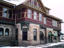 Big Four Depot |
July 7, 1975 (#75001350) |
Southeastern corner of Church and Washington Sts. 40°44′04″N 82°47′02″W |
Galion | |
| 3 | Herbert S. Blair House | 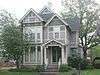 Herbert S. Blair House |
March 24, 1980 (#80002969) |
212 S. Lane St. 40°48′25″N 82°58′19″W |
Bucyrus | |
| 4 | Brownella Cottage and Grace Episcopal Church and Rectory | 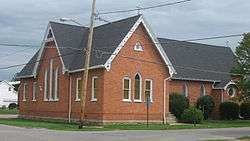 Brownella Cottage and Grace Episcopal Church and Rectory |
September 27, 1980 (#80002975) |
S. Union and Walnut Sts. 40°43′58″N 82°47′28″W |
Galion | |
| 5 | Bucyrus Commercial Historic District | 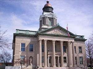 Bucyrus Commercial Historic District |
February 28, 1985 (#85000401) |
Sandusky Ave. and Mansfield St. 40°48′31″N 82°58′32″W |
Bucyrus | |
| 6 | Bucyrus Mausoleum | 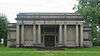 Bucyrus Mausoleum |
September 27, 1980 (#80002970) |
Southern Ave. 40°47′49″N 82°59′08″W |
Bucyrus | |
| 7 | Central Hotel, Hackedorn and Zimmerman Building | 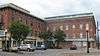 Central Hotel, Hackedorn and Zimmerman Building |
November 13, 1976 (#76001386) |
Southwestern corner of Harding Way E. and Market Sts. 40°44′01″N 82°47′24″W |
Galion | |
| 8 | Dr. John Chesney House | 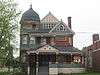 Dr. John Chesney House |
March 24, 1980 (#80002971) |
225 E. Mansfield St. 40°48′30″N 82°58′21″W |
Bucyrus | |
| 9 | Col. William Crawford Capture Site | 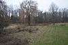 Col. William Crawford Capture Site |
April 3, 1979 (#79002812) |
0.5 miles east of State Route 598 and County Road 229, east of Leesville 40°47′51″N 82°46′56″W |
Jefferson Township | |
| 10 | Crestline City Hall | .jpg) Crestline City Hall |
May 8, 1974 (#74001427) |
121 W. Bucyrus St. 40°47′03″N 82°45′04″W |
Crestline | |
| 11 | Stephen R. Harris House | 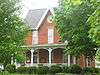 Stephen R. Harris House |
July 24, 1980 (#80002972) |
548 East St. 40°48′12″N 82°58′14″W |
Bucyrus | |
| 12 | Harvey One-Room School | 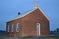 Harvey One-Room School |
March 17, 2010 (#10000083) |
1120 Caldwell Rd., southwest of Bucyrus 40°44′49″N 83°03′32″W |
Bucyrus Township | |
| 13 | Heckler Farmhouse | 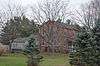 Heckler Farmhouse |
May 3, 1976 (#76001385) |
North of downtown Crestline off State Route 61 on Oldfield Rd. 40°47′55″N 82°44′16″W |
Crestline | |
| 14 | Hoffman House | 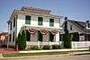 Hoffman House |
November 29, 1978 (#78002030) |
211 Thoman St. 40°47′08″N 82°44′17″W |
Crestline | |
| 15 | Hosford House | 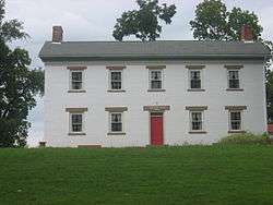 Hosford House |
April 30, 1976 (#76001387) |
6288 Hosford Rd., southwest of Galion 40°43′24″N 82°49′00″W |
Polk Township | |
| 16 | Adam Howard House | 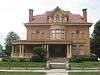 Adam Howard House |
March 30, 1978 (#78002032) |
230 S. Boston St. 40°43′53″N 82°47′36″W |
Galion | |
| 17 | J & M Trading Post | 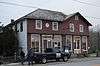 J & M Trading Post |
April 3, 1979 (#79002811) |
6867 Leesville Rd. in Leesville 40°47′43″N 82°47′18″W |
Jefferson Township | |
| 18 | J & M Trading Post - Annex | 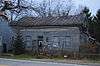 J & M Trading Post - Annex |
April 3, 1979 (#79002809) |
Leesville Rd. in Leesville 40°47′43″N 82°47′17″W |
Jefferson Township | |
| 19 | Leesville Town Hall | 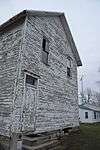 Leesville Town Hall |
April 3, 1979 (#79002810) |
State Route 598 and County Road 229 in Leesville 40°47′44″N 82°47′18″W |
Jefferson Township | |
| 20 | McGraw House | 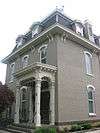 McGraw House |
July 18, 1975 (#75001349) |
116 S. Walnut St. 40°48′29″N 82°58′26″W |
Bucyrus | |
| 21 | Methodist Episcopal Church | 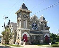 Methodist Episcopal Church |
October 27, 1978 (#78002031) |
Thoman and Union Sts. 40°47′08″N 82°44′18″W |
Crestline | |
| 22 | Monnett Memorial M. E. Chapel | 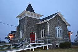 Monnett Memorial M. E. Chapel |
December 29, 1986 (#86003494) |
999 State Route 98, southwest of Bucyrus 40°44′21″N 82°59′35″W |
Bucyrus Township | |
| 23 | D. Picking and Company | 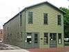 D. Picking and Company |
July 11, 1974 (#74001425) |
119 S. Walnut St. 40°48′29″N 82°58′28″W |
Bucyrus | |
| 24 | Scroggs House | 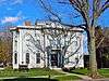 Scroggs House |
October 9, 1974 (#74001426) |
202 S. Walnut St. 40°48′27″N 82°58′26″W |
Bucyrus | |
| 25 | Smith Road Bridge | .jpg) Smith Road Bridge |
October 7, 1980 (#80002973) |
Northwest of Bucyrus 40°55′37″N 83°02′08″W |
Lykens Township | |
| 26 | Toledo and Ohio Central Depot | 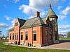 Toledo and Ohio Central Depot |
October 3, 1980 (#80002974) |
700 E. Rensselaer St. 40°48′28″N 82°58′02″W |
Bucyrus |
Former listing
| [3] | Name on the Register | Image | Date listed | Date removed | Location | City or town | Summary |
|---|---|---|---|---|---|---|---|
| 1 | Calvary Reformed Church | November 29, 1978 (#78002029) | February 20, 1980 | Thoman and John Sts. |
Crestline |
gollark: Fascinating.
gollark: I thought they stopped hereditary peerages from hereditating.
gollark: In a very real sense, all code in C is extremely horribly unsafe until you prove otherwise.
gollark: yes.
gollark: C++ is like C but stupider and more complicated.
See also
| Wikimedia Commons has media related to National Register of Historic Places in Crawford County, Ohio. |
References
- The latitude and longitude information provided in this table was derived originally from the National Register Information System, which has been found to be fairly accurate for about 99% of listings. Some locations in this table may have been corrected to current GPS standards.
- "National Register of Historic Places: Weekly List Actions". National Park Service, United States Department of the Interior. Retrieved on August 14, 2020.
- Numbers represent an ordering by significant words. Various colorings, defined here, differentiate National Historic Landmarks and historic districts from other NRHP buildings, structures, sites or objects.
- "National Register Information System". National Register of Historic Places. National Park Service. April 24, 2008.
- The eight-digit number below each date is the number assigned to each location in the National Register Information System database, which can be viewed by clicking the number.
Municipalities and communities of Crawford County, Ohio, United States | ||
|---|---|---|
| Cities | Map of Ohio highlighting Crawford County | |
| Villages | ||
| Townships | ||
| CDPs | ||
| Unincorporated communities | ||
| Footnotes | ‡This populated place also has portions in an adjacent county or counties | |
This article is issued from Wikipedia. The text is licensed under Creative Commons - Attribution - Sharealike. Additional terms may apply for the media files.