Colorado State Highway 370
State Highway 370 (SH 370) is a state highway near Alamosa, Colorado. SH 370's western terminus is at SH 15 near Monte Vista National Wildlife Refuge, and the eastern terminus is at U.S. Route 285 (US 285) south of Alamosa.
| ||||
|---|---|---|---|---|
| Road 10S | ||||
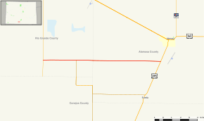 Map of southern Colorado with SH 370 highlighted in red | ||||
| Route information | ||||
| Maintained by CDOT | ||||
| Length | 14.115 mi[1] (22.716 km) | |||
| Major junctions | ||||
| West end | ||||
| East end | ||||
| Location | ||||
| Counties | Alamosa, Rio Grande | |||
| Highway system | ||||
Colorado State Highways
| ||||

Route description
SH 370 runs 14.1 miles (22.7 km), starting at a junction with SH 15 near Monte Vista National Wildlife Refuge and ending straight east at a junction with US 285 just south of Alamosa.
Major intersections
| County | Location | mi | km | Destinations | Notes |
|---|---|---|---|---|---|
| Rio Grande | | 0.000 | 0.000 | Western terminus; road continues as Road 10S | |
| | 3.99 | 6.42 | Western terminus of SH 368 | ||
| Alamosa | | 14.115 | 22.716 | Eastern terminus; road continues as Road 10S | |
| 1.000 mi = 1.609 km; 1.000 km = 0.621 mi | |||||
gollark: Yep!
gollark: osmarks.tk operates *various* quantum computers for purposes.
gollark: Sure.
gollark: Quantum computers can also not magically accelerate all operations magically.
gollark: Shor's algorithm? Yes. HOWEVER, there are algorithms designed to not be attacked by quantum stuff, yes.
References
- "Segment list for SH 370". Retrieved 2011-01-22.
External links
This article is issued from Wikipedia. The text is licensed under Creative Commons - Attribution - Sharealike. Additional terms may apply for the media files.