Colorado State Highway 368
State Highway 368 (SH 368) is a state highway near Alamosa, Colorado. SH 368's western terminus is at SH 370 southeast of Monte Vista, and the eastern terminus is at U.S. Route 285 (US 285) north of Estrella.
| ||||
|---|---|---|---|---|
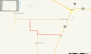 Map of southern Colorado with SH 368 highlighted in red | ||||
| Route information | ||||
| Maintained by CDOT | ||||
| Length | 12.329 mi[1] (19.842 km) | |||
| Major junctions | ||||
| West end | ||||
| East end | ||||
| Location | ||||
| Counties | Alamosa, Conejos, Rio Grande | |||
| Highway system | ||||
Colorado State Highways
| ||||

Route description
SH 368 runs 12.3 miles (19.8 km), starting at a junction with SH 370, heading south to a junction with SH 371, then heading east to its end at a junction with US 285.
Major intersections
| County | Location | mi | km | Destinations | Notes |
|---|---|---|---|---|---|
| Rio Grande | | 0.000 | 0.000 | Western terminus; road continues north as CR 4E | |
| Conejos–Alamosa county line | | 6.022 | 9.691 | Northern terminus of SH 371 | |
| Alamosa | Estrella | 12.329 | 19.842 | US 285 / SH 17 | Eastern terminus; road continues as CR RD 14 S |
| 1.000 mi = 1.609 km; 1.000 km = 0.621 mi | |||||
gollark: Offer your soul to their obviously superior development team?
gollark: Yes. The food pellet things it eats are packages. The ghosts are dependency version conflicts.
gollark: This is *peak* design.
gollark: It contains !!ROUNDED CORNERS!!, arbitrarily changes the button layouts, has excessive whitespace, *gradients*, and also a hamburger menu despite having tons of free room for links.
gollark: It does not have to look like that, bee.
References
- "Segment list for SH 368". Retrieved 2011-01-22.
External links
This article is issued from Wikipedia. The text is licensed under Creative Commons - Attribution - Sharealike. Additional terms may apply for the media files.