Colorado State Highway 317
State Highway 317 (SH 317) is a 12.237-mile-long (19.694 km) state highway in the US state of Colorado. The western terminus is at SH 13 in Hamilton, and the eastern terminus is at Routt County Route 29 (CR 29).
| ||||
|---|---|---|---|---|
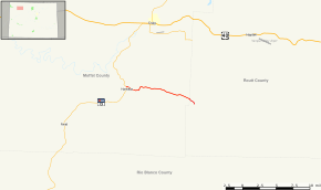 Map of northwestern Colorado with SH 317 highlighted in red | ||||
| Route information | ||||
| Maintained by CDOT | ||||
| Length | 12.237 mi[1] (19.694 km) | |||
| Major junctions | ||||
| West end | ||||
| East end | ||||
| Location | ||||
| Counties | Moffat, Routt | |||
| Highway system | ||||
Colorado State Highways
| ||||

Route description
SH 317 runs 12.2 miles (19.6 km), starting at a junction with SH 13 in Hamilton. The highway follows the Williams Fork River to the east and ends at a junction with CR 29 just over the Routt County line.
Major intersections
| County | Location | mi | km | Destinations | Notes |
|---|---|---|---|---|---|
| Moffat | Hamilton | 0.000 | 0.000 | Western terminus | |
| Routt | | 12.237 | 19.694 | Eastern terminus | |
| 1.000 mi = 1.609 km; 1.000 km = 0.621 mi | |||||
gollark: OH REALLY?
gollark: I mean, as I said, I don't expect skynet use to actually reach a point where there are more than even 10 servers.
gollark: Um... that doesn't really help...
gollark: By the way I use arch.
gollark: 2. install Arch Linux.
References
- "Segment list for SH 317". Retrieved 2011-01-22.
External links
This article is issued from Wikipedia. The text is licensed under Creative Commons - Attribution - Sharealike. Additional terms may apply for the media files.