Colorado State Highway 127
State Highway 127 (SH 127) is a 9.202-mile-long (14.809 km) state highway in far northern Colorado.
| ||||
|---|---|---|---|---|
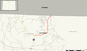 Map of Jackson County in northern Colorado with SH 127 highlighted in red | ||||
| Route information | ||||
| Maintained by CDOT | ||||
| Length | 9.2 mi[1] (14.8 km) | |||
| Major junctions | ||||
| South end | ||||
| North end | ||||
| Location | ||||
| Counties | Jackson | |||
| Highway system | ||||
Colorado State Highways
| ||||

Route description
SH 127 begins in the south at its junction with SH 125 roughly four miles north of Cowdrey and proceeds generally northeast to the Wyoming state line where it becomes Wyoming Highway 230 towards Laramie, WY.
Major intersections
The entire route is in Jackson County. [2]
| Location[2] | mi[2] | km | Destinations | Notes | |
|---|---|---|---|---|---|
| | 0.000 | 0.000 | Southern terminus | ||
| 9.202 | 14.809 | Continuation beyond Wyoming state line | |||
| 1.000 mi = 1.609 km; 1.000 km = 0.621 mi | |||||
gollark: <@165858230327574528> Someone on here had a SQLite peripheral.
gollark: If you already have code for it, would that not be a PR?
gollark: That's actually how I found out the details of one potatospotatoexploit™.
gollark: Although you can, as it turns out, read printed pages held in other people's hands, which is neat.
gollark: Plethora doesn't let you access metadata sometimes even when it would be very !!FUN!!.]
References
- "Segment Descriptions for Highway 127". Colorado Department of Transportation. Retrieved 2010-01-23.
- "Highway Data Explorer, Online Transportation Information System". Colorado Department of Transportation. Archived from the original on September 10, 2012. Retrieved October 2, 2016.
This article is issued from Wikipedia. The text is licensed under Creative Commons - Attribution - Sharealike. Additional terms may apply for the media files.