Clay Township, Butler County, Kansas
Clay Township is a township in Butler County, Kansas, USA. As of the 2000 census, its population was 83.
Clay Township | |
|---|---|
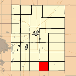 Location in Butler County | |
| Coordinates: 37°31′30″N 096°46′51″W | |
| Country | United States |
| State | Kansas |
| County | Butler |
| Area | |
| • Total | 36.43 sq mi (94.36 km2) |
| • Land | 36.35 sq mi (94.15 km2) |
| • Water | 0.08 sq mi (0.21 km2) 0.22% |
| Elevation | 1,381 ft (421 m) |
| Population (2000) | |
| • Total | 83 |
| • Density | 2.3/sq mi (0.9/km2) |
| GNIS feature ID | 0470031 |
History
Clay Township was created in 1879.[1]
Geography
Clay Township covers an area of 36.43 square miles (94.4 km2) and contains no incorporated settlements. According to the United States Geological Survey, it contains two cemeteries: Bryant and Lone Star.
The stream of North Branch Rock Creek runs through this township.
Further reading
gollark: libarchive?
gollark: How combinatorial.
gollark: `(lisp (lisp (lisp palaiologos)))`
gollark: `(lisp palaiologos)`
gollark: palaiologos: https://discord.com/channels/346530916832903169/348702212110680064/806846148554784789
References
- Mooney, Vol. P. (1916). History of Butler County Kansas. Standard Publishing Company. pp. 111.
External links
Municipalities and communities of Butler County, Kansas, United States | ||
|---|---|---|
| Cities | 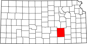 Map of Kansas highlighting Butler County | |
| Unincorporated communities | ||
| Ghost towns | ||
| Townships | ||
| Footnotes | †This populated place is designated a Census-Designated Place (CDP) by the United States Census Bureau, ‡This populated place also has portions in an adjacent county or counties. | |
| Authority control |
|
|---|
This article is issued from Wikipedia. The text is licensed under Creative Commons - Attribution - Sharealike. Additional terms may apply for the media files.