Cimarron, Colorado
Cimarron is an unincorporated community and U.S. Post Office in Montrose County, Colorado, United States. The Cimarron Post Office has the ZIP Code 81220.[2]
Cimarron, Colorado | |
|---|---|
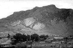 In 1883 | |
 Cimarron, Colorado Location within the state of Colorado | |
| Coordinates: 38°26′30″N 107°33′22″W | |
| Country | |
| State | |
| County | Montrose County |
| Elevation | 2,102 m (6,896 ft) |
| Time zone | UTC-7 (MST) |
| • Summer (DST) | UTC-6 (MDT) |
| ZIP Code | 81220[2] |
Cimarron is a small unincorporated community on the Cimarron River, just south of the Black Canyon of the Gunnison, and just outside Curecanti National Recreation Area. The D & RG Narrow Gauge Trestle crosses the Cimarron River gorge just northeast of town, and is on the National Register of Historic Places (#76000172).
Geography
Cimarron is located at 38°26′30″N 107°33′22″W (38.441758,-107.555981).

Round-up in a ranch just south of the town, 1898.
gollark: > It is similar in concept to SVG (Scalable Vector Graphics) but much simpler. Compared to SVG Tiny, which isn't actually tiny, it does not have features for text, multimedia, interactivity, linking, scripting, animation, XSLT, DOM, combination with raster graphics such as JPEG formatted textures, etc.
gollark: https://github.com/google/iconvg is a similar thing.
gollark: Haiku has a cool compact format for icons (HVIF).
gollark: Mostly SVG, there aren't widely deployed good alternatives.
gollark: It's ridiculously verbose and XMLy. Even the "tiny" SVG standards allow stuff like embedded CSS and *JavaScript*.
See also
- Outline of Colorado
- State of Colorado
- Colorado cities and towns
- Colorado counties
- Colorado metropolitan areas
- Montrose, CO Micropolitan Statistical Area
- Black Canyon of the Gunnison National Park
- Cimarron River
- Curecanti National Recreation Area
- D & RG Narrow Gauge Trestle
- Morrow Point Dam
References
- "US Board on Geographic Names". United States Geological Survey. 2007-10-25. Retrieved 2008-01-31.
- "ZIP Code Lookup". United States Postal Service. December 15, 2006. Archived from the original (JavaScript/HTML) on September 3, 2007. Retrieved December 15, 2006.
Municipalities and communities of Montrose County, Colorado, United States | ||
|---|---|---|
| City | 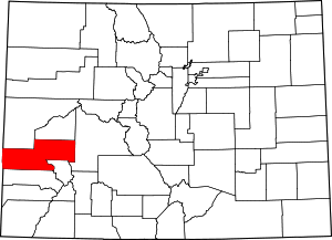 Map of Colorado highlighting Montrose County | |
| Towns | ||
| CDP | ||
| Unincorporated communities | ||
| Ghost town | ||
| Authority control |
|
|---|
This article is issued from Wikipedia. The text is licensed under Creative Commons - Attribution - Sharealike. Additional terms may apply for the media files.