Chiloango River
The Chiloango River[1] (Portuguese: Rio Chiluango[2], also known as Kakongo River,[3] Louango,[4] Shiloango[5] and Rio Hi[6]) is a river in western Central Africa. It forms the westernmost part of the border between the Democratic Republic of the Congo and the Republic of Congo, and then forms approximately half of the border between the DRC and Cabinda, Angola[7] passing just south of the town of Necuto. The river then bisects Cabinda, making it the most important river in the province.[8] It enters the Atlantic Ocean just north of the town of Cacongo.[9][10]
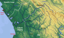
Chiloango River basin
Notes
- Chiloango River (Variant) at GEOnet Names Server, United States National Geospatial-Intelligence Agency
- Chiluango, Rio (Approved - Angola) at GEOnet Names Server, United States National Geospatial-Intelligence Agency
- Kakongo River (Variant) at GEOnet Names Server, United States National Geospatial-Intelligence Agency
- Louango (Approved - Congo, Republic of the) at GEOnet Names Server, United States National Geospatial-Intelligence Agency
- Shiloango (Approved - Congo, Democratic Republic of the) at GEOnet Names Server, United States National Geospatial-Intelligence Agency
- Hi, Rio (Variant) at GEOnet Names Server, United States National Geospatial-Intelligence Agency
- International Boundary Study No. 105 – October 15, 1970: Angola (Cabinda) – Republic of the Congo (Brazzaville) Boundary Archived June 7, 2011, at the Wayback Machine The Geographer, Office of the Geographer, Bureau of Intelligence and Research, U.S. State Department, Washington, D.C.
- Frenken, Karen (1997) Irrigation potential in Africa: A basin approach (FAO Land and Water Bulletin 4) Land and Water Development Division of the Food and Agriculture Organization of the United Nations, Rome. Italy, www.fao.org "Table 71 Rivers and discharges", ISBN 92-5-103966-6
- National Geographic Atlas of the World: Revised Sixth Edition, National Geographic Society, 1992
- United States. Hydrographic Office (1916) Africa Pilot: The southewest coast of Africa from Cape Palmas to the Cape of Good Hope, including the islands of St. Helena, Ascension, Tristan da Cunha, and neighboring islands Hydrographic Office, Washington, D.C., volume 1, page 346 OCLC 62355097
| Congo left bank (south) |  | |
|---|---|---|
| Kasai basin | ||
| Congo right bank (north) | ||
| Lualaba and tributaries | ||
| Other | ||
gollark: <@412680539624046592> "the same as" how?
gollark: Also, all hail pattern matching, down with switch statements!
gollark: Personally, I think stuff isn't pre-planned, but that stuff is deterministic.
gollark: Whatever that is.
gollark: Ah, don't worry, TJ09 only complains about reverse engineering which goes against ***The Great Vision***.
This article is issued from Wikipedia. The text is licensed under Creative Commons - Attribution - Sharealike. Additional terms may apply for the media files.