Childress, Montgomery County, Virginia
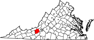
Childress is an unincorporated community in Montgomery County, Virginia, United States. Childress is located on State Route 693 7.3 miles (11.7 km) southwest of Christiansburg.
Childress, Virginia | |
|---|---|
Unincorporated community | |
 National Register of Historic Places located near Childress, Virginia. Top: Bowyer-Trollinger Farm; Bottom L-R: Thomas Hall House and Cromer House. | |
 Childress  Childress  Childress | |
| Coordinates: 37°03′22″N 80°30′16″W | |
| Country | United States |
| State | Virginia |
| County | Montgomery |
| Elevation | 1,946 ft (593 m) |
| Time zone | UTC-5 (Eastern (EST)) |
| • Summer (DST) | UTC-4 (EDT) |
| Area code(s) | 540 |
| GNIS feature ID | 1477201[1] |
History
Childress contained a post office from 1852 until 1952.[2] The original name of the post office, Childress Store, honors three brothers named Childress who kept a store in the community.[3]
The Bowyer-Trollinger Farm, Cromer House, and Thomas Hall House are listed on the National Register of Historic Places.[4]
gollark: Although we had those for 3.3 time.
gollark: Heavserver has stage channels. Maybe it dislikes them.
gollark: Is it in any new guilds? Did heavserver beeize it somehow?
gollark: I think they just removed some events unless you turned on the intents, which shouldn't do that.
gollark: Hmm, were there some gateway changes? I forget.
References
- "Childress". Geographic Names Information System. United States Geological Survey.
- "Montgomery County". Jim Forte Postal History. Archived from the original on 6 October 2014. Retrieved 28 September 2014.
- Tennis, Joe (2004). Southwest Virginia Crossroads: An Almanac of Place Names and Places to See. The Overmountain Press. p. 140. ISBN 978-1-57072-256-1.
- "National Register Information System". National Register of Historic Places. National Park Service. July 9, 2010.
This article is issued from Wikipedia. The text is licensed under Creative Commons - Attribution - Sharealike. Additional terms may apply for the media files.
