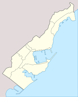
Chemin des Révoires
The Chemin des Révoires is a pathway within Les Révoires district of the Principality of Monaco. It is the highest point in Monaco.
| Chemin des Révoires | |
|---|---|
 Chemin des Révoires Location in Monaco (on the border with France) | |
| Highest point | |
| Elevation | 162 m (531 ft) |
| Prominence | 0 (slope point) [1] |
| Listing | Country high point |
| Coordinates | 43°44′4.45″N 7°24′46.3″E |
| Geography | |
| Location | Monaco - France border |
| Parent range | Maritime Alps |
Features
The highest point in Monaco, at 162 metres (528 feet) above sea level, is situated on this pathway, on the slopes of Mont Agel, a mountain whose summit is situated on the French side. A proportion of the Principality's territory is very steep, being geographically part of the Alps which extend to the Mediterranean Sea.
gollark: Well, if you're arguing based on it, I think it would be useful to know.
gollark: Is this actually true?
gollark: I think the more interesting question is what it's actually doing at a high level, i.e. what algorithms the entire accursedly complex mess runs. There might be a relatively nice explanation which covers some parts.
gollark: Neurons are apparently individually about as complex as a large computer "DNN".
gollark: The components aren't really understood either.
See also
- Geography of Monaco
References
- "Chemin des Révoires, Monaco/France". Peakbagger.com. Retrieved 2014-08-02.
This article is issued from Wikipedia. The text is licensed under Creative Commons - Attribution - Sharealike. Additional terms may apply for the media files.