Charlestown Bridge
The Charlestown Bridge, officially named the North Washington Street Bridge, is located in Boston and spans the Charles River. As the river's easternmost crossing, the bridge connects the neighborhoods of Charlestown and the North End. Completed in 1900 and given its current official name in 1910,[1] the bridge carries a portion of the Freedom Trail linking to the USS Constitution and Bunker Hill. To the north of the bridge, Route 99 begins and the street becomes New Rutherford Avenue.[2]
Charlestown Bridge | |
|---|---|
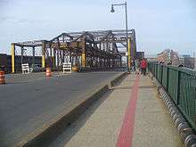 Charlestown Bridge, looking north. The red line on the pavement indicates the Freedom Trail. | |
| Coordinates | 42°22′08″N 71°03′36″W |
| Carries | North Washington Street |
| Crosses | Charles River |
| Locale | Boston, Massachusetts |
| Official name | North Washington Street Bridge |
| Maintained by | City of Boston |
| Characteristics | |
| Design | Plate girder bridge approaches, with truss swing span |
| Total length | 1,089 ft (332 m) |
| Width | 66 ft (20 m) |
| No. of spans | One (241.2 ft (73.5 m)) |
| History | |
| Designer | William Jackson |
| Construction start | 1898 |
| Construction end | 1900 |
| Opened | 1900 |
| Replaces | Charles River Bridge (1786) |
| Statistics | |
| Daily traffic | 38,400 cars/day (2010) |
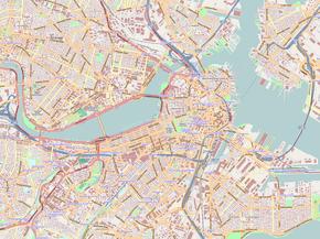 Charlestown Bridge Location in Boston  Charlestown Bridge Charlestown Bridge (Massachusetts) | |
Replacement of the bridge started in fall 2018 and is expected to be completed in 2023.[3]
History
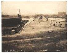
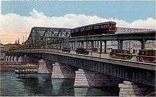
The first government-sanctioned ferry crossing of the Charles was chartered at this location in the 1630s. It was operated by various individuals until it was given to Harvard College "in perpetuity" in 1640, to support the college financially. In 1640, the Massachusetts General Court granted Harvard College the revenue from the Boston-Charlestown ferry to help support the institution. The Harvard Corporation in its capacity managed the Charlestown ferry from the 1640s until 1785, and after the completion of the Charles River Bridge in 1785.[4]
The first bridge on this site was known as the Charles River Bridge, chartered in 1785 and opened on June 17, 1786. As a condition of chartering the bridge, a sum of £200 was paid annually to Harvard College to compensate for the lost ferry income. The bridge was privately built and operated, with tolls producing profits for the investors during the charter period, after the initial expense was paid off. In 1792, the West Boston Bridge was chartered, connecting West Boston to Cambridge. In compensation, the legislature extended the charter period of the Charles River Bridge by 30 years, but the unpopular double tolls on Sundays were eliminated.[5] Traffic to the bridge was facilitated by the laying out of the Medford Turnpike in 1803.
When the Warren Bridge was chartered in 1828 in a location extremely close to the Charles River Bridge, the investors filed a lawsuit which eventually reached the United States Supreme Court as Charles River Bridge v. Warren Bridge.
The current bridge was built in 1900 under chief engineer William Jackson, and was designed to carry the Charlestown Elevated railway in addition to vehicle traffic. However, the railway was demolished in 1975 to make way for its replacement, the MBTA Orange Line's Haymarket North Extension. The new line was rerouted to avoid having to pass directly through the densely populated Charlestown neighborhood. The Haymarket Tunnel, emerging from under both North Station and the Charles River just south of the new Orange Line Community College station, was inaugurated in 1975 as the designated tunnel for Orange Line trains.[6] Because the bridge was originally designed to accommodate an elevated railroad in addition to automobiles, the bridge spans six lanes.
The bridge formerly carried the southernmost stretch of Massachusetts Route 99 to its terminus at the river, but following completion of the Big Dig in the late 2000s, the route's designation was changed to relocate the terminus to Chelsea Street in Charlestown.
Replacement
The bridge has been considered structurally deficient since 2003, when the center two lanes were permanently closed. Construction work on a replacement bridge began in the fall of 2018. The design for the new bridge, by architect Miguel Rosales in collaboration with Alfred Benesch & Co., is intended to complement the nearby Zakim Bridge (with which Rosales was also involved). The new bridge is slated to have two vehicular lanes in each direction, a dedicated southbound bus lane, and a protected bicycle lane and sidewalk on each side. During construction, a temporary bridge is planned to be installed to carry pedestrians and three lanes of vehicular traffic.[7][8][9]
Gallery
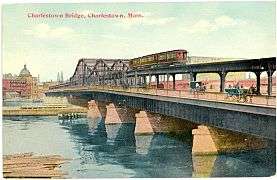 Bridge and Elevated Railway (1912)
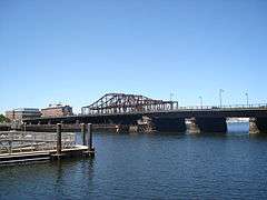 Bridge and approaches, with Charlestown in the background
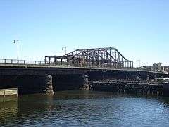 The former trackbed of the Charlestown Elevated railway can still be seen in the bridge superstructure.
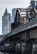 View towards downtown Boston and the Custom House Tower
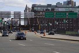 Bridge approaches looking into downtown Boston
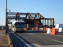 Bus 111 on the bridge
References
- Boston (Mass.) Board of Street Commissioners (1910). Board of Street Commissioners proceedings (Report). 40. City of Boston Archives. p. 4.
- Hoth, Nathan. "North Washington Street Bridge". historicbridges.org. Historic Bridges. Retrieved March 13, 2019.
- "N Washington Street Bridge Construction Underway; Public Receives Updates at North End Meeting". Charlestown Patriot-Bridge. November 29, 2018. Retrieved April 13, 2019.
- Boston (Mass.). Transit Commission; George Glover Crocker (1899). The Ferry, the Charles-River Bridge and the Charlestown Bridge: Historical Statement. Rockwell & Churchill. pp. 3–.
- Bacon's dictionary of Boston by Edwin Monroe Bacon and George Edward Ellis. p. 69.
- Andrew Elder and Jeremy C. Fox (October 21, 2013). Boston's Orange Line. Arcadia Publishing. pp. 8–. ISBN 978-1-4671-2047-0.
- "North Washington Street Bridge Project Approved". NorthEndWaterfront.com. March 20, 2018. Retrieved April 13, 2019.
- "Mayor's Column: How We're Working to Replace the Charlestown Bridge". Charlestown, MA Patch. Patch Media. December 7, 2018. Retrieved April 13, 2019.
- Baumann, Edward T. (November 2, 2018). "The gentler of the two". Roads & Bridges. Scranton Gillette Communications. Retrieved April 13, 2019.
External links
| Wikimedia Commons has media related to Charlestown Bridge. |
