Champtoceaux
Champtoceaux is a former commune in the Maine-et-Loire department of western France. On 15 December 2015, it was merged into the new commune Orée-d'Anjou.[2]
Champtoceaux | |
|---|---|
Part of Orée-d'Anjou | |
Location of Champtoceaux 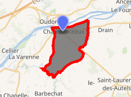
| |
 Champtoceaux  Champtoceaux | |
| Coordinates: 47°20′16″N 1°15′56″W | |
| Country | France |
| Region | Pays de la Loire |
| Department | Maine-et-Loire |
| Arrondissement | Cholet |
| Canton | La Pommeraye |
| Commune | Orée-d'Anjou |
| Area 1 | 15.54 km2 (6.00 sq mi) |
| Population (2017)[1] | 2,504 |
| • Density | 160/km2 (420/sq mi) |
| Time zone | UTC+01:00 (CET) |
| • Summer (DST) | UTC+02:00 (CEST) |
| Postal code | 49270 |
| Elevation | 2–86 m (6.6–282.2 ft) (avg. 71 m or 233 ft) |
| 1 French Land Register data, which excludes lakes, ponds, glaciers > 1 km2 (0.386 sq mi or 247 acres) and river estuaries. | |
History
Champtoceaux name derives from Latin Castrum Sellense. Inhabitants are called Castrocelsiens today.
Twin towns


gollark: Well, right now, nothing, it stopped several hours ago.
gollark: So we can only really say "maybe (but probably not)".
gollark: You're making statements dependent on understanding of those universal laws, which is not complete.
gollark: Also, apparently FTL travel is equivalent to time travel, thus problems.
gollark: Procrastinating on homework is much more fun than actually doing it.
References
- Téléchargement du fichier d'ensemble des populations légales en 2017, INSEE
- Arrêté préfectoral, 25 November 2015 (in French)
External links
| Wikimedia Commons has media related to Champtoceaux. |
| Authority control |
|
|---|
This article is issued from Wikipedia. The text is licensed under Creative Commons - Attribution - Sharealike. Additional terms may apply for the media files.