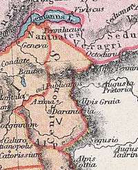
Ceutrones
The Ceutrones (variant: Centrones) were a Gallic tribe of the La Tène and Roman periods. They controlled the Graian Alps regions of Gallia Viennensis Quinta in Gallia Narbonensis.

Note: Lake Geneva is shown at the top
Name
They are mentioned as Ceutrones by Caesar (mid-1st c. BC),[1] as Keútrōnes (Κεύτρωνες; var. Κέντρωνες) by Strabo (early 1st c. AD),[2] as Ceutrones by Pliny (1st c. AD),[3] and as Keutrónōn (Κευτρόνων) by Ptolemy (2nd c. AD).[4][5]
History
According to d’Anville, the Ceutrones occupied most of the Tarentaise Valley in the modern department of Savoie, France. Pliny the Elder called them "borders," that is, people living on the western border of the Alps. Ptolemy places them in the Graian Alps occupying the regions west of the Aosta Valley inhabited by the Salassi.
The Ceutrones had a sizeable population readily willing to defend themselves, probably with well cultivated lands, according to written accounts by great armies that passed through. Polybius describes how the Ceutrones aggressively attacked Caesar’s army on its march through the Alps to Lake Bourget. The onslaught included by an assault by rolling rocks and stones in the mountainous passes, and inflicted great losses of life on the Roman forces. Polybius also describes a meeting by envoys of the Ceutrones with Hannibal.
The Ceutrones are mentioned by Caesar (Commentarii de Bello Gallico, 1.10):
- ... Here (in the Alps) the Ceutrones and the Graioceli and the Caturiges, having taken possession of the higher parts, attempt to obstruct the army in their march. After having routed these in several battles, he arrives in the territories of the Vocontii in the Further Province on the seventh day from Ocelum, which is the most remote town of the Hither Province; thence he leads his army into the country of the Allobroges, ...[6]
A Roman inscription about the Ceutrones from Axima (Aime) has survived.
Settlements by the tribe were identified by Ptolemy in his Geographia, and some appear on the Tabula Peutingeriana. One of the most important cultural centers was Darantasia, which gave the Tarentaise Valley and region its name. Medieval clergy made this city an important religious center before the end of the first millennium. They called it Monasterium, which became Moûtiers, by which it is now known.
The village of Centron in Montgirod, Savoie, likely the place known as Forum Claudii Ceutronum under the Romans, preserves the tribal name.
Several tribes were immediate neighbors of the Ceutrones and occupied territories that partly overlapped with theirs. These include:
- the Allobroges, who reached into the northwest of Savoy (western Haute Savoie department);
- the Graioceli, in the upper valley of Maurienne and in the vicinity of Alpis Graia (modern Little St Bernard Pass), as well as in adjoining sections of northwestern Piedmont in the Graian Alps;
- the Medulli, who occupied the middle Maurienne Valley and probably reached as far as Darantasia itself;[7]
- the Nantuates in the Chablais savoyard (eastern Haute Savoie department) and adjoining sections of Canton Valais;
- the above-mentioned Salassi of Aosta Valley; and
- the Segusini whose territory included Susa and Briançon.
Major settlements
- Darantasia, also called Ceutronum Civitas and Solins (Moûtiers)
- Ad Publicanos (Conflans, in Albertville)
- Arebrigium, also called Oblimum (Saint-Didier, in La Bâthie)
- Axima, also called Axuma (Aime)
- Bergintium (Bourg-Saint-Maurice)
- Clusora (Cluses)
- Forum Claudii Ceutronum (?, probably Centron, near Montgirod, if it is not the same as Darantasia[7])
- Mantala (Bourg-Evescal, between Saint-Jean-de-la-Porte and Saint-Pierre-d'Albigny)
See also
- Allobroges
- Graioceli
- Medulli
- Nantuates
- Segusini
- List of Celtic tribes
- List of peoples of Gaul
- Gaulish language
- Ancient Diocese of Tarentaise
References
- Caesar. Commentarii de Bello Gallico, 1:10:4
- Strabo. Geōgraphiká, 4:6:6
- Pliny. Naturalis Historia, 3:135
- Ptolemy. Geōgraphikḕ Hyphḗgēsis, 3:1:33
- Falileyev 2010, p. entry 3829b.
- Caesar, Bell. Gall. I 10,4
- "William Hazlitt, The Classical Gazetteer (1851), p. 132". Archived from the original on 2011-06-06. Retrieved 2009-09-04.
References
- Falileyev, Alexander (2010). Dictionary of Continental Celtic Place-names: A Celtic Companion to the Barrington Atlas of the Greek and Roman World. CMCS. ISBN 978-0955718236.
Sources
- John Lemprière, Lorenzo DaPonte, & John David Ogilby (1839), Bibliotheca Classica: or, A Dictionary of All the Principal Names and Terms, (Tenth American edition), New York: W. E. Dean. Centrones, p. 69
- Henry Lewis Wickham, John Anthony Cramer (1820). A Dissertation on the Passage of Hannibal Over the Alps, (Second edition, 1828), London: G. B. Whittaker, pp. 41–67
- William Hazlitt (1851). The Classical Gazetteer: a Dictionary of Ancient Geography, Sacred and Profane, London: Whittaker and Co.
- Venceslas Kruta, Les Celtes, Histoire et Dictionnaire (Collection "Bouquins".) Paris: Éditions Robert Laffont, 2000 ISBN 2-7028-6261-6.
