Central Scranton Expressway
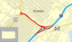
The Central Scranton Expressway is a short freeway southeast of downtown Scranton in the Commonwealth of Pennsylvania. It runs east-southeast from U.S. Route 11 (US 11) and Pennsylvania Route 307 (PA 307) near downtown to Interstate 81 (I-81).
| Central Scranton Expressway | |
|---|---|
 | |
| Route information | |
| Maintained by PennDOT | |
| Length | 0.9 mi[1] (1.4 km) |
| Existed | 1964–present |
| Major junctions | |
| West end | |
| East end | |
| Highway system | |
| |
The highway is one of only two freeways in Pennsylvania with no posted route number (the other being the Airport Connector near Harrisburg). In the Location Referencing System, it is designated State Route 3022 by the Pennsylvania Department of Transportation.
Route description
The Central Scranton Expressway begins at an interchange with US 11, PA 307, and Cedar Avenue in Scranton, heading east-southeast on a four-lane freeway. The road runs between residential neighborhoods to the southwest and Roaring Brook to the northeast. The freeway passes under the new Harrison Avenue Bridge before ending at an interchange with I-81.[1]
History
Construction began in 1964 alongside the adjacent section of I-81.[2] The road was built along a portion of the former Lackawanna and Wyoming Valley Railroad right-of-way passing beneath the Harrison Avenue Bridge.[3] It opened with a temporary western terminus feeding into Front Street at Prospect Avenue. By the early 1970s, the current interchange at the western terminus was opened, connecting to a new road replacing the demolished Spruce Street Bridge.
Exit list
The entire route is in Scranton, Lackawanna County.
| mi[1] | km | Destinations | Notes |
|---|---|---|---|
| 0.0 | 0.0 | Cedar Avenue | Western terminus |
| 0.9 | 1.4 | Eastern terminus | |
| 1.000 mi = 1.609 km; 1.000 km = 0.621 mi | |||
References
- Google (2010-12-24). "overview of Central Scranton Expressway" (Map). Google Maps. Google. Retrieved 2010-12-24.
- Jeffrey J. Kitsko (September 30, 2014). "Pennsylvania Highways: Interstate 81". Pennsylvania Highways. Retrieved September 29, 2018.
- Henwood, James N. J.; Muncie, John G. (1986). Laurel Line: An Anthracite Region Railway. Glendale, California: Interurban Press. p. 186. ISBN 0916374726.
See also


- North Scranton Expressway