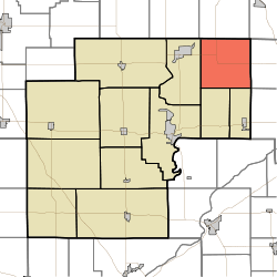
Cass Township, White County, Indiana
Cass Township is one of twelve townships in White County, Indiana, United States. As of the 2010 census, its population was 585 and it contained 228 housing units.[1]
Cass Township | |
|---|---|
 Location in White County | |
| Coordinates: 40°52′11″N 86°38′20″W | |
| Country | United States |
| State | Indiana |
| County | White |
| Government | |
| • Type | Indiana township |
| Area | |
| • Total | 36.19 sq mi (93.7 km2) |
| • Land | 36.19 sq mi (93.7 km2) |
| • Water | 0 sq mi (0 km2) 0% |
| Elevation | 696 ft (212 m) |
| Population (2010) | |
| • Total | 585 |
| • Density | 16.2/sq mi (6.3/km2) |
| ZIP codes | 46978, 46985, 47926, 47950, 47960 |
| GNIS feature ID | 453169 |
Cass Township was established in 1848.[2] The township was named for Gen. Lewis Cass, Governor of Michigan Territory.[3]
Geography
According to the 2010 census, the township has a total area of 36.19 square miles (93.7 km2), all land.[1]
Unincorporated towns
(This list is based on USGS data and may include former settlements.)
Adjacent townships
- Indian Creek Township, Pulaski County (north)
- Van Buren Township, Pulaski County (northeast)
- Boone Township, Cass County (east)
- Jefferson Township, Cass County (southeast)
- Jackson Township (south)
- Lincoln Township (south)
- Liberty Township (west)
Cemeteries
The township contains Bell Center Cemetery.
School districts
- Pioneer Regional School Corporation
- Twin Lakes School Corporation
Political districts
- Indiana's 2nd congressional district
- State House District 16
- State Senate District 07
gollark: * originally
gollark: I'm still using a spare 5-year-old phone belonging to Zachary.
gollark: My political beliefs are randomly generated every 73 hours.
gollark: π√4 or so.
gollark: Why would I support them?
References
- United States Census Bureau 2007 TIGER/Line Shapefiles
- United States Board on Geographic Names (GNIS)
- IndianaMap
- "Population, Housing Units, Area, and Density: 2010 - County -- County Subdivision and Place -- 2010 Census Summary File 1". United States Census. Archived from the original on 2020-02-12. Retrieved 2013-05-10.
- Hamelle, W. H. (1915). A Standard History of White County, Indiana: An Authentic Narrative of the Past, with an Extended Survey of Modern Developments in the Progress of Town and Country. Unigraphic. p. 273.
- "Pioneer Consolidated School How It Gets Its Name". The Royal Centre Record. April 21, 1961. p. 1. Retrieved 1 May 2015.
This article is issued from Wikipedia. The text is licensed under Creative Commons - Attribution - Sharealike. Additional terms may apply for the media files.