Carterway Heads
Carterway Heads is a village in Northumberland, England.[1][2] It is situated between Consett and the Derwent Reservoir, at the intersection of the A68 and B6278 roads.
| Carterway Heads | |
|---|---|
 Carterway Heads Location within Northumberland | |
| OS grid reference | NZ045515 |
| Unitary authority | |
| Ceremonial county | |
| Region | |
| Country | England |
| Sovereign state | United Kingdom |
| Post town | CONSETT |
| Postcode district | DH8 |
| Dialling code | 01207 |
| Police | Northumbria |
| Fire | Northumberland |
| Ambulance | North East |
| UK Parliament | |
Governance
Carterway Heads is in the parliamentary constituency of Hexham.
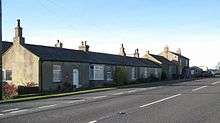
Cottages in Carterway Heads, 2008
gollark: I see.
gollark: Well, I've initiated PROJECT NUMERATE POLYMER now.
gollark: Not *always*. I need some messages as "templates", obviously.
gollark: I didn't actually turn up, I just have a bot generate plausibly-from-me-looking messages at random times when other people are active.
gollark: I may have to keep Project NAMEPLATE EQUALIZER on standby.
References
| Wikimedia Commons has media related to Carterway Heads. |
- Ordnance Survey: Landranger map sheet 87 Hexham & Haltwhistle (Map). Ordnance Survey. 2009. ISBN 9780319231678.
- "Ordnance Survey: 1:50,000 Scale Gazetteer" (csv (download)). www.ordnancesurvey.co.uk. Ordnance Survey. 1 January 2016. Retrieved 30 January 2016.
This article is issued from Wikipedia. The text is licensed under Creative Commons - Attribution - Sharealike. Additional terms may apply for the media files.