Caramoan Peninsula
Caramoan Peninsula is a hilly peninsula in north-east Camarines Sur, Bicol, Philippines with deep gorges and a rough, rocky terrain. It contains the Caramoan National Park and is also an Important Bird Area with habitat for the green racket-tail (Prioniturus luconensis).[1]
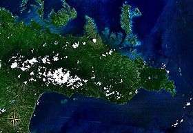
Caramoan Peninsula seen from space
Caramoan National Park
| Caramoan National Park | |
|---|---|
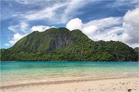 Pitogo Island off Caramoan Peninsula | |
| Location | Camarines Sur, Bicol, Philippines |
| Coordinates | 13.800°N 123.882°E[2] |
| Area | 347 ha (860 acres) |
| Established | 1938 |
The peninsula contains the 347-hectare (860-acre) Caramoan National Park which was established in 1938.[3] The park has caves, limestone formations, white sandy beaches, an islet lake and a subterranean river, make it popular with tourists. It is accessible by public transport from the town of Caramoan, and local people have established trails in the park for visitors.
gollark: That was after mattie came up with kristmail nonsense.
gollark: `Remind me why we need sending to ourselves?`
gollark: Oh, D3Matt? He said earlier "you should just ban sending to yourself".
gollark: Is who?
gollark: <@168591260280553472> If sending to yourself is banned, consider the viability of sending krist between two wallets you control instead.
References
- "Caramoan peninsula". BirdLife International. Retrieved December 31, 2012.
- "Caramoan National Park". protectedplanet.net.
- "Proclamation No. 291, s. 1938". Official Gazette of the Republic of the Philippines. Retrieved December 31, 2012.
This article is issued from Wikipedia. The text is licensed under Creative Commons - Attribution - Sharealike. Additional terms may apply for the media files.