Caicó
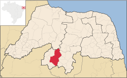
Caicó, also known as the City of Prince, is a municipality in the Seridó Ocidental microrregion and Central Potiguar mesorregion, in Rio Grande do Norte state, Northeast Brazil. With a population of 62,709 inhabitants (2010), it is the seventh most populous city of Rio Grande do Norte and the second in the countryside of the state, after Mossoró.
Caicó City of Prince | |
|---|---|
Municipality | |
Caicó | |
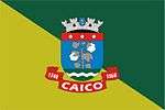
 Flag .png) Seal | |
 | |
| Country | |
| Region | Nordeste |
| State | Rio Grande do Norte |
| Mesoregion | Central Potiguar |
| Government | |
| • Type | Democracy |
| • Mayor | Roberto Germano |
| Population | |
| • Total | 62,709 |
| Time zone | UTC -3 |
| Caicó | |
Located between the Seridó and Barra Nova rivers, in the eastern portion of Western Seridó, the city has the highest human development index of the Semi-arid Northeast Brazil. Founded in 1735 as Vila Nova do Príncipe, the city has evolved into a political and cultural centre of Rio Grande do Norte. The name "Caicó" is derived from the indigenous word Queicuó, meaning "Cuó River and Mountain".
History
The settlement was made initially by migrants of Pernambuco in search of land for cattle ranching, since the Royal Charter of 1701 prohibited cattle on the coast. Were awarded land grants as rewards for military shapes such as the expulsion of the Dutch and for priests, with the construction of the chapel in honor of St. Anne in 1695. In 1700 gave up the foundation of the Camp Queiquó by Manuel de Souza Forte. However the first families to settle fully took place from 1720, by Portuguese coming mainly from northern Portugal and the Azores.
Geography
Climate
Caicó has a hot semi-arid climate (Köppen climate classification BSh), subject to variability, and the dry periods (droughts) may last more than one year. Rain falls between February and May, with an average annual precipitation of 700 millimetres or 27.6 inches. There are about 3,000 hours of average sunshine annually.[1][2] Beside Mossoró and Pau dos Ferros, both in Western Rio Grande do Norte, Caicó is one of the hottest cities in the state[3] with temperatures reaching up to 38 °C (100 °F) during the day.[4]
According to the Brazilian National Institute of Meteorology, since 1995 the lowest temperature recorded in Caicó was 16.3 °C (61.3 °F) on March 16, 2008,[5] and the highest reached 40 °C (104 °F) on January 18, 2003 and January 28, 2007.[6] The highest cumulative rainfall recorded in 24 hours was 171.2 millimetres (6.7 in) on January 22, 1996.[7]
| Climate data for Caicó | |||||||||||||
|---|---|---|---|---|---|---|---|---|---|---|---|---|---|
| Month | Jan | Feb | Mar | Apr | May | Jun | Jul | Aug | Sep | Oct | Nov | Dec | Year |
| Record high °C (°F) | 40 (104) |
39.2 (102.6) |
39.8 (103.6) |
39.2 (102.6) |
38.6 (101.5) |
36.6 (97.9) |
37.6 (99.7) |
37.6 (99.7) |
38.8 (101.8) |
39.8 (103.6) |
39.8 (103.6) |
39.8 (103.6) |
40 (104) |
| Average high °C (°F) | 33.4 (92.1) |
33 (91) |
32.3 (90.1) |
31.5 (88.7) |
30.4 (86.7) |
29.1 (84.4) |
29 (84) |
29.7 (85.5) |
31.4 (88.5) |
32.7 (90.9) |
33.3 (91.9) |
33.5 (92.3) |
31.6 (88.9) |
| Daily mean °C (°F) | 28.1 (82.6) |
27.8 (82.0) |
27.5 (81.5) |
27.1 (80.8) |
26.4 (79.5) |
25.4 (77.7) |
25 (77) |
25.4 (77.7) |
26.5 (79.7) |
27.2 (81.0) |
27.8 (82.0) |
28 (82) |
26.9 (80.4) |
| Average low °C (°F) | 22.8 (73.0) |
22.7 (72.9) |
22.7 (72.9) |
22.7 (72.9) |
22.5 (72.5) |
21.8 (71.2) |
21.1 (70.0) |
21.1 (70.0) |
21.6 (70.9) |
21.8 (71.2) |
22.3 (72.1) |
22.6 (72.7) |
22.1 (71.8) |
| Record low °C (°F) | 20.4 (68.7) |
20.2 (68.4) |
16.3 (61.3) |
16.8 (62.2) |
17 (63) |
18 (64) |
17.4 (63.3) |
17.6 (63.7) |
19 (66) |
20.2 (68.4) |
20.4 (68.7) |
20.2 (68.4) |
16.3 (61.3) |
| Average rainfall mm (inches) | 54 (2.1) |
112 (4.4) |
198 (7.8) |
170 (6.7) |
66 (2.6) |
29 (1.1) |
19 (0.7) |
5 (0.2) |
2 (0.1) |
3 (0.1) |
6 (0.2) |
32 (1.3) |
696 (27.4) |
| Source 1: Climate Data;[1] | |||||||||||||
| Source 2: Brazilian National Institute of Meteorology (extremes since March 14, 1995).[5][6] | |||||||||||||
Demographics
The 2010 census had the municipality's population as 62,709, width a density of 53,9 persons per km².[8] Caicó's median age of 27, as well as its percentage of seniors are above the state average and the national average, while those under 15 are below Brazilian percentages. Around 92% describe themselves as Christian, with Catholics account for 90,4% of the population and members of Protestant churches is 2.3%. The city is the seat of the Roman Catholic Diocese of Caicó. Ethnically, 59% are white, 35% mixed, 4% black, and 1% Asian.
References
- "Climate: Caicó". Climate Data. Archived from the original on August 18, 2015. Retrieved August 17, 2015.Archive index at the Wayback Machine
- "Características da Região do Seridó" (in Portuguese). Retrieved September 7, 2016.
- Márcio Costa (March 4, 2007). "Mossoró, Pau dos Ferros e Caicó são as cidades mais quentes do RN" (in Portuguese). O Mossoroense. Archived from the original on September 3, 2014. Retrieved August 17, 2015.
- "Verão 2013 pode ser o mais quente dos últimos anos" (in Portuguese). Jornal de Hoje. December 21, 2012. Archived from the original on June 19, 2015. Retrieved August 17, 2015.
- "BDMEP - Série Histórica - Dados Diários - Temperatura Mínima (°C) - Seridó (Caicó)" (in Portuguese). Brazilian National Institute of Meteorology. Retrieved August 17, 2015.
- "BDMEP - Série Histórica - Dados Diários - Temperatura Máxima (°C) - Seridó (Caicó)". Retrieved August 17, 2015.
- "BDMEP - Série Histórica - Dados Diários - Precipitação (mm) - Seridó (Caicó)" (in Portuguese). Brazilian National Institute of Meteorology. Retrieved August 17, 2015.
- "Tabela 2.1 - População residente, total, urbana total e urbana na sede municipal, em números absolutos e relativos, com indicação da área total e densidade demográfica, segundo as Unidades da Federação e os municípios – 2010" (in Portuguese). Brazilian Institute of Geography and Statistics. Retrieved August 17, 2015.