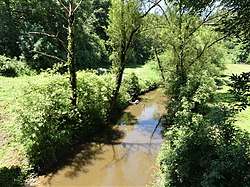
Céor
The Céor (French: le Céor) is a 55.9 km (34.7 mi) long river in the Aveyron department in southern France. Its source is at Salles-Curan, 3.5 km (2.2 mi) southwest of the lac de Pareloup. It flows generally west-southwest. It is a left tributary of the Viaur, into which it flows at Saint-Just-sur-Viaur.
| Céor | |
|---|---|
 | |
| Location | |
| Country | France |
| Physical characteristics | |
| Source | |
| • location | Salles-Curan |
| • coordinates | 44°09′47″N 02°41′42″E |
| • elevation | 910 m (2,990 ft) |
| Mouth | |
• location | Viaur |
• coordinates | 44°07′27″N 02°29′29″E |
• elevation | 305 m (1,001 ft) |
| Length | 55.9 km (34.7 mi) |
| Basin size | 340 km2 (130 sq mi) |
| Discharge | |
| • average | 4.6 m3/s (160 cu ft/s) |
| Basin features | |
| Progression | Viaur→ Aveyron→ Tarn→ Garonne→ Gironde estuary→ Atlantic Ocean |
Communes along its course
This list is ordered from source to mouth:
Notes
- This article is based on the equivalent article from the French Wikipedia, consulted on 6 May 2009.
gollark: It's being crashy today.
gollark: pjals: um, no.
gollark: Cactus you.
gollark: <@151391317740486657>
gollark: Skynet is functioning as usual.
This article is issued from Wikipedia. The text is licensed under Creative Commons - Attribution - Sharealike. Additional terms may apply for the media files.