Byfield National Park
Byfield is a national park in the Shire of Livingstone, Queensland, Australia.[1]
| Byfield National Park Queensland | |
|---|---|
IUCN category II (national park) | |
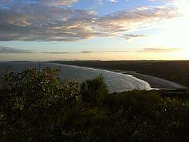
 Nine Mile Beach, Byfield National Park | |
 Byfield National Park | |
| Coordinates | 22°47′02″S 150°43′54″E |
| Established | 1988 |
| Area | 87 km2 (33.6 sq mi) |
| Managing authorities | Queensland Parks and Wildlife Service |
| See also | Protected areas of Queensland |
Geography

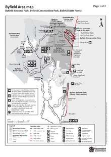
Byfield National Park map, 2018
The park is 70 km north-east of Rockhampton.[2] The parks encloses 12 km of coastline including four beaches.[3]
To the north of the national park is Shoalwater Bay and Byfield State Forest is located to the west of Byfield National Park.
The park contains a number of four-wheel drive tracks and camping areas.[4]
Water Park Creek within the park contains a population of Rhadinocentrus ornatus, a small freshwater fish species.[5]
Climate
The park demarcates the southern boundary of a tropical savannah climate (Köppen: Aw), although the subtropics are almost a degree to the south.[6]
gollark: Idea: ABR bridge to ##electronics from <#746231084353847366>.
gollark: So you can't really just introduce that at random.
gollark: USING it usefully requires, I think, rather good™ metalworking capabilities.
gollark: I see.
gollark: A philosophy is a kind of monoid, in the category of endofunctors.
See also
References
- "Byfield National Park (entry 39396)". Queensland Place Names. Queensland Government. Retrieved 26 June 2017.
- Byfield National Park and Conservation Park. Department of National Parks, Recreation, Sport and Racing. Retrieved 15 May 2013.
- Short, Andrew D. (2000). Beaches of the Queensland Coast, Cooktown to Coolangatta: A Guide to Their Nature, Characteristics, Surf and Safety. Sydney University Press. p. 236. ISBN 0958650411. Retrieved 12 May 2013.
- "Byfield Miners Playgrounds". Queensland Weekender. 3 November 2012. Archived from the original on 27 June 2013. Retrieved 12 May 2013.
- Pusey, Brad; Mark Kennard; Angela Arthington (2004). Freshwater Fishes of North-Eastern Australia. Csiro Publishing. p. 199. ISBN 064309895X. Retrieved 12 May 2013.
- "Interactive Australia / New Zealand Koppen-Geiger Climate Classification Map". www.plantmaps.com. Retrieved 6 March 2019.
This article is issued from Wikipedia. The text is licensed under Creative Commons - Attribution - Sharealike. Additional terms may apply for the media files.