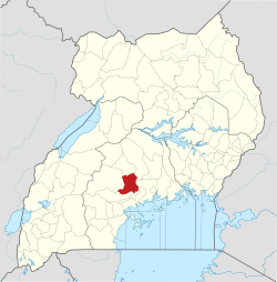
Busunju
Busunju is a town in the Mityana District in the Central Region of Uganda.[1]
Busunju | |
|---|---|
 Busunju Location in Uganda | |
| Coordinates: 00°33′56″N 32°12′13″E | |
| Country | |
| Region | Central Region |
| District | Mityana District |
| County | Ssingo |
| Constituency | Mityana East |
| Elevation | 3,870 ft (1,180 m) |
Location
Busunju lies along the Kampala–Hoima Road, and is the northern end of the Kampala–Busunju Expressway.[2] It is approximately 59 kilometres (37 mi), by road, northwest of Kampala, Uganda's capital and largest city.[3] The coordinates of the town are 0°33'56.0"N, 32°12'13.0"E (Latitude:0.565568; Longitude:32.203603).[4]
gollark: ++help tel
gollark: <@356107472269869058>
gollark: Did NOBODY notice the acronym issue?
gollark: Maybe it doesn't like parsing your form somehow.
gollark: Odd.
See also
References
- El-Shahat, Samah (8 February 2008). "THE VILLAGE: Busunju" (Video). Aljazeera.com. Retrieved 19 February 2016.
- Nasasira, John (16 January 2011). "Nasasira: Do not judge our performance basing on sorry Kampala roads". The Observer (Uganda). Kampala. Retrieved 19 February 2016.
- GFC (19 February 2016). "Distance between Kampala Road, Kampala, Central Region, Uganda and St. Padre Pio Primary School, Kampala-Hoima Road, Mityana District, Central Region, Uganda". Globefeed.com (GFC). Retrieved 19 February 2016.
- Google (19 February 2016). "Location of Busunju, Mityana District, Uganda" (Map). Google Maps. Google. Retrieved 19 February 2016.
This article is issued from Wikipedia. The text is licensed under Creative Commons - Attribution - Sharealike. Additional terms may apply for the media files.
