Bura, Tana River County
Bura | |
|---|---|
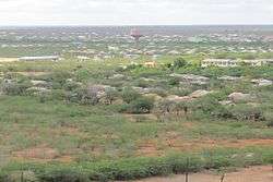 Skyline of Bura town. | |
| Country | Kenya |
| County | [Tana River County] |
| Elevation | 105 m (344 ft) |
| Time zone | UTC+3 (EAT0) |
Bura is a town in Tana River County, Kenya.
Location
The town lies on the west bank of the Tana River, approximately 50 km north of Hola, the headquarters of Tana River County, and about 100 km south of Garissa town. The coordinates of Bura are: 1°11'39.1S, 39°50'23.0"E (Latitude:-1.503606; Longitude:39.837802).[1]

Bura
Bura (Kenya)
Overview
Bura is also known as Bura-Tana and Bura-West with postal code 70104. [2]The town is the centre of Bura Irrigation and Settlement Project. The water treatments works in Bura town are a land mark that can be seen from 20 km. Bura West hosts Bura airport (IATA: n/a, ICAO: HKBR), which sits at an average altitude of 344 feet (105 m).[3][4]
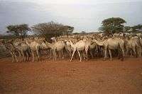
Watering point in Tana River County, near Bura, Kenya
gollark: We sell excellent high-quality orbital nukes for a wide variety of budgets, helpfully.
gollark: Nuke it from orbit. It's the only way to be sure.
gollark: Kamlialisp may be dangerous to your mental health.
gollark: That *is* entirely consistent with how you type.
gollark: That's just defensive.
References
- Google (7 February 2017). "Location of Bura, Tana River County, Kenya" (Map). Google Maps. Google. Retrieved 7 February 2017.
- There exist no other town in Kenya with the name Bura in its postal code.
- Aviador (13 September 2016). "Airport Information: Bura (Kenya)". Aviador.es. Retrieved 13 September 2016.
- Bura is also the name of an administrative division in Garissa County. The headquarters of this administrative area are located in Bura East, but the larger part of Bura East township, if not all, is located in Tana River District as the border of Tana River County (formerly Tana District) is not the river as some people erroneously think, but roughly three miles of land along the Tana River are part of Tana River County.
External links
This article is issued from Wikipedia. The text is licensed under Creative Commons - Attribution - Sharealike. Additional terms may apply for the media files.