Bundesstraße 23
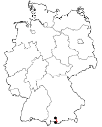
Bundesstraße 23 (abbreviated to B 23) is a German federal highway (German: Bundesstraße) in Bavaria that runs from Peiting to the Austrian border near Garmisch-Partenkirchen. The road is partially a part of the “German Alpine Road” (German: Deutsche Alpenstraße). The B 23 which together with the Bundesstraße 17 and Bundesstraße 472 the quickest way from Augsburg to Garmisch-Partenkirchen, continue along the Bundesstraße 2 to Mittenwald, Innsbruck and the Brenner Pass.
| ||||||||||||||||||||||||||||||||||||||||||||||||||||||||||||
|---|---|---|---|---|---|---|---|---|---|---|---|---|---|---|---|---|---|---|---|---|---|---|---|---|---|---|---|---|---|---|---|---|---|---|---|---|---|---|---|---|---|---|---|---|---|---|---|---|---|---|---|---|---|---|---|---|---|---|---|---|
| Bundesstraße 23 | ||||||||||||||||||||||||||||||||||||||||||||||||||||||||||||
 | ||||||||||||||||||||||||||||||||||||||||||||||||||||||||||||
| Route information | ||||||||||||||||||||||||||||||||||||||||||||||||||||||||||||
| Length | 59.2 km (36.8 mi) | |||||||||||||||||||||||||||||||||||||||||||||||||||||||||||
| Major junctions | ||||||||||||||||||||||||||||||||||||||||||||||||||||||||||||
| North end | Peiting | |||||||||||||||||||||||||||||||||||||||||||||||||||||||||||
| ||||||||||||||||||||||||||||||||||||||||||||||||||||||||||||
| South end | Austrian border near Garmisch-Partenkirchen | |||||||||||||||||||||||||||||||||||||||||||||||||||||||||||
| Location | ||||||||||||||||||||||||||||||||||||||||||||||||||||||||||||
| States | Bavaria | |||||||||||||||||||||||||||||||||||||||||||||||||||||||||||
| Highway system | ||||||||||||||||||||||||||||||||||||||||||||||||||||||||||||
Course
The B 23 starts at the B 472 (bypass Schongau - Peiting) exit Peiting-south in the Weilheim-Schongau district and initially leads to Rottenbuch. A few years ago, this stretch was in a poor state of development, during which some more serious accidents have occurred. In recent years, this segment has been widened.
After the main through-road of Rottenbuch reaches the line the “Echelsbacher Brücke”. The 183 m long and 76 m high arch bridge spanning the Ammer. On the bridge there is also the border of the district of Garmisch-Partenkirchen.
The road passes Bad Bayersoien and reaches Saulgrub. Currently, a local diversion around Saulgrub is being built to ease traffic congestion from through traffic. In Saulgrub, the B 23 meets the Ammergau Railway (Murnau / Oberammergau) for the first time.
It follows village Unterammergau. The road pass the local diversion of Oberammergau and reach Ettal. After the road cross the village, it achieve the “Ettaler Sattel” (869 NHN) the highest point on the route. The way winding along twisting road into Loisachtal. Here reaches the route Oberau and the Bundesstraße 2. The two roads run parallel to six kilometers (3.7 miles) towards the south. After the bypass Farchant separates the B 23 from the B 2 and runs in a southwesterly direction to Garmisch-Partenkirchen.
After B 23 has crossed Griesen, the route ends at the border with Austria (Tyrol), where it merges into the Austrian B 187 (towards Lermoos, Fernpassstraße, Inn valley).
History
Origins
Probably in the Roman period, but no later than at the time Louis IV, there was a connection between the Via Claudia in the Lech Valley to the Brenner road in the Loisach Valley.
The most difficult part of this route led from Rottenbuch to Bad Bayersoien by Echelsbach gorge. Therefore between 8 November 1928 and 27 April 1930 Echelsbacher Brücke was built for ℛℳ 900 000 .
Former routes and designations
The Bundesstraße 23 arise from Reichsstraße 23 at 1949. At that time, the R 23 began in Peiting at the intersection "Schongauer Straße" / "Oberere Straße" / "Guggenbergerstraße" at the then R 17 and ended in Oberau at the junction with the R 2. With the introduction of the Bundesstraßen the B 23 was extended on Farchant to Garmisch-Partenkirchen. There they led to the B 24.[1]
Alterations
The Local diversion Oberammergau opened to traffic in 1989.[2]
The extension of the route from Garmisch-Partenkirchen to the Austrian border at Griesen in 1991. The B 24 was integrate in the new B 23. The remainder in Garmisch-Partenkirchen municipality was downgraded.
In 1991, following the release a segment of the bypass Schongau - Peiting the beginning of the B 23 changed to B 17 exit Peiting-West. The main through-road of Peiting was downgraded to a state road (German: Staatsstraße). The relocation to the present location was made after completion of bypass Schongau - Peiting in 1997
In May 2000 the Farchanter Tunnel was opened.[3]
Further expansion
Currently (March 2010) the following expansion in planning or under construction:
- Eastern local diversion Saulgrub (Progress since February 2009 under construction)[4]
- Local diversion Oberau (urgent needs in the Federal Transport Infrastructure Plan 2003)[5]
- Garmisch-Partenkirchen western local diversion with Kramertunnel (planning: an action against the zoning decision on 23 June 2009)[4]
Tourism
Scenic Routes
Between the St2059 (near Rottenbuch) and Garmisch-Partenkirchen, leads the “German Alpine Road” (German: Deutsche Alpenstraße) along the B 23.
Attractions
Among the sights along the route:
- "Augustiner-Chorherrenstift" in Rottenbuch
- "Echelsbacher Brücke" between Rottenbuch and Bad Bayersoien
- with "Lüftlmalerei" decorated facades in Oberammergau
- Oberammergau Passion Play
- Linderhof Palace between Oberammergau and Ettal
- Ettal Abbey
Scenic routes
The entire route is scenic. Put the divided:
- Alpine foothills (Peiting till Saulgrub)
- Ammergau Alps (Saulgrub till Ettal)
- Bavarian Prealps and Loisachtal (Ettal till Garmisch-Partenkirchen)
- Wetterstein with Zugspitze (Garmisch-Partenkirchen till Austrian border)
Spas
Along the route are the spas Bad Bayersoien, Bad Kohlgrub and Ettal.
See also
References
- Wasow, Carsten. "Die Bundes- und ehemaligen Reichsstraßen in Deutschland" [The federal highways and former "Reichsstraßen" in Germany] (in German). reichsstrassen.de.vu. p. B 11–100. Archived from the original on 2012-09-07. Retrieved 24 July 2010.
- Historischer Verein Oberammergau 1999 e.V. "Geschichte der Gemeinde Oberammergau" [History of Oberammergau] (in German). Oberammergau. Archived from the original on 19 July 2011. Retrieved 24 July 2010.
- Brandner, Joseph. "Farchanter Ortschronik" [History from Farchant] (in German). Farchant: Tourist-Information Farchant. Archived from the original on 25 May 2010. Retrieved 24 July 2010.
Im Mai 2000 wird der Farchanter Tunnel eröffnet – die Ortsumgehung entlastet täglichen Durchgangsverkehr.
- Staatliches Bauamt Weilheim. "Projekte aus dem Bereich Straßenbau" [Projects related to road construction] (in German). Weilheim. Retrieved 24 July 2010.
- Government of the Federal Republic of Germany (2 July 2003). "Bundesverkehrswegeplan 2003" [Federal Transport Infrastructure Plan 2003] (PDF) (in German). Berlin: Bundesministerium für Verkehr, Bau und Stadtentwicklung. Archived from the original (pdf–2393KByte) on 2011-07-16. Retrieved 24 July 2010.
External links
| Wikimedia Commons has media related to Bundesstraße 23. |
