Bulgaria–Romania border
The Bulgaria–Romania border (Bulgarian: Граница между България и Румъния, romanized: Granitsa mezhdu Bŭlgariya i Rumŭniya, Romanian: Frontiera între Bulgaria și România) is the state border between Bulgaria and Romania.
| Bulgaria–Romania border Граница между България и Румъния Granița între Bulgaria și România | |
|---|---|
 | |
| Characteristics | |
| Entities | |
| Length | 631.3 kilometers |
| History | |
| Established | 1878 Signing of the Treaty of San Stefano at the end of the Russo-Turkish War (1877–1878) |
| Current shape | 1940 Treaty of Craiova |
| Treaties | Treaty of San Stefano (1878) Treaty of Berlin (1878) Saint Petersburg Conference (1913) Treaty of Bucharest (1913) Treaty of Bucharest (1918) Treaty of Neuilly-sur-Seine (1919) Treaty of Craiova (1940) Paris Peace Treaties (1947) |
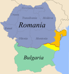
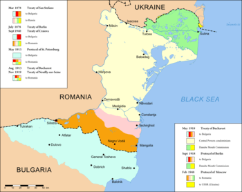
For most of its length, the border follows the course of the lower Danube River, up until the town of Silistra. From Silistra, the river continues north into the Romanian territory. East of that point, the land border passes through the historical region of Dobruja, dividing it into Northern Dobruja in Romania and Southern Dobruja in Bulgaria.
The Bulgaria–Romania border is an internal border of the European Union. However, as of 2020 neither country is part of the Schengen Area. As a result, border controls are conducted between the two countries, albeit often jointly (once per crossing).
Border crossings
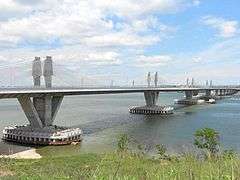
- Vidin–Calafat (New Europe Bridge): road, railway
- Oryahovo-Bechet: ferry
- Nikopol-Turnu Măgurele: ferry
- Svishtov-Zimnicea: ferry
- Ruse–Giurgiu (Danube Bridge): road, railway
- Silistra–Ostrov: road
- Kaynardzha–Lipnița: road[1]
- Kardam–Negru Vodă: road, railway
- Durankulak–Vama Veche: road
Maps
 Bulgarian-Romanian border in Dobruja (in red)
 Border changes in Dobruja since 1878
References
| Wikimedia Commons has media related to Bulgaria-Romania border. |
- "Romania, Bulgaria Open New Border Crossing". New York Times. 3 October 2017. Retrieved 4 October 2017.