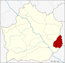
Bueng Samakkhi District
Bueng Samakkhi (Thai: บึงสามัคคี, pronounced [bɯ̄ŋ sǎː.mák.kʰīː]) is a district (amphoe) in the eastern part of Kamphaeng Phet Province, central Thailand.
Bueng Samakkhi บึงสามัคคี | |
|---|---|
 Bueng Samakkhi | |
 District location in Kamphaeng Phet Province | |
| Coordinates: 16°11′18″N 99°58′39″E | |
| Country | Thailand |
| Province | Kamphaeng Phet |
| Seat | Wang Cha-on |
| Area | |
| • Total | 377.186 km2 (145.632 sq mi) |
| Population (2005) | |
| • Total | 26,663 |
| • Density | 70.7/km2 (183/sq mi) |
| Time zone | UTC+7 (ICT) |
| Postal code | 62210 |
| Geocode | 6210 |
History
Tambon Rahan, Wang Cha-on, and Bueng Samakkhi were separated from Khanu Woralaksaburi district to form the minor district (king amphoe) Bueng Samakkhi on 30 April 1994.[1] The government selected the name Bueng Samakkhi to commemorate the unity of the people in the district.
On 15 May 2007, all 81 minor districts were upgraded to full districts.[2] On August 24 the upgrade became official.[3]
Geography
Neighboring districts are (from the south clockwise) Khanu Woralaksaburi, Khlong Khlung, Sai Thong Watthana of Kamphaeng Phet Province, Sam Ngam, Pho Prathap Chang and Bueng Na Rang of Phichit Province.
Administration
The district is divided into four sub-districts (tambons), which are further subdivided into 45 villages (mubans). There are no municipal (thesaban) areas. There are four tambon administrative organizations (TAO).
| No. | Name | Thai name | Villages | Pop. | |
|---|---|---|---|---|---|
| 1. | Bueng Samakkhi | บึงสามัคคี | 12 | 4,917 | |
| 2. | Wang Cha-on | วังชะโอน | 14 | 9,028 | |
| 3. | Rahan | ระหาน | 10 | 7,532 | |
| 4. | Thep Nimit | เทพนิมิต | 9 | 5,186 |
References
- ประกาศกระทรวงมหาดไทย เรื่อง แบ่งเขตท้องที่อำเภอขาณุวรลักษบุรี จังหวัดกำแพงเพชร ตั้งเป็นกิ่งอำเภอบึงสามัคคี (PDF). Royal Gazette (in Thai). 111 (42 ง): 25. May 26, 1994.
- แถลงผลการประชุม ครม. ประจำวันที่ 15 พ.ค. 2550 (in Thai). Manager Online.
- พระราชกฤษฎีกาตั้งอำเภอฆ้องชัย...และอำเภอเหล่าเสือโก้ก พ.ศ. ๒๕๕๐ (PDF). Royal Gazette (in Thai). 124 (46 ก): 14–21. August 24, 2007.