Broad Bottom, Kentucky
Broad Bottom is an unincorporated community in Pike County, Kentucky, United States.[1]
Broad Bottom, Kentucky | |
|---|---|
 Broad Bottom, Kentucky  Broad Bottom, Kentucky | |
| Coordinates: 37°32′03″N 82°35′35″W | |
| Country | United States |
| State | Kentucky |
| County | Pike |
| Elevation | 663 ft (202 m) |
| Time zone | UTC-5 (Eastern (EST)) |
| • Summer (DST) | UTC-4 (EDT) |
| GNIS feature ID | 507587[1] |
History
Broad Bottom was named for its location "in a low-lying area" next to Levisa Fork.[2] A post office opened in 1924, and closed in 1984.[2][3] Broad Bottom was a flag stop on the Big Sandy Subdivision of the Chesapeake and Ohio Railway.[4]
gollark: ++remind "I mean the year 2022, NOT the hour, you useless parser, and the fourth quarter (q4) of it" palaiolgogoso
gollark: ++remind "year 2022, fourth quarter" palaiologos
gollark: ...
gollark: ++remind "2022 Q4" do
gollark: 1. initial esolangs2. ???3. ???4. ???5. palaiologistic era
References
- U.S. Geological Survey Geographic Names Information System: Broad Bottom
- Rennick, Robert M. (1984). Kentucky Place Names. University Press of Kentucky. p. 36.
- "Kentucky, Pike County". Jim Forte Postal History. Retrieved January 22, 2020.
- "Timetable No. 138" (PDF). The Chesapeake and Ohio Railway Company. April 27, 1952.
Municipalities and communities of Pike County, Kentucky, United States | ||
|---|---|---|
| Cities | 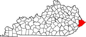 Location of Pike County, Kentucky | |
| CDPs | ||
| Other unincorporated communities |
| |
| Ghost towns | ||
This article is issued from Wikipedia. The text is licensed under Creative Commons - Attribution - Sharealike. Additional terms may apply for the media files.