Break O'Day Council
Break O'Day Council is a local government body in Tasmania, situated in the northern part of the state's east coast. Break O'Day is classified as a rural local government area and has a population of 6,232,[1] the major towns of the region include St Helens, St Marys and Scamander.
| Break O'Day Council Tasmania | |||||||||||||||
|---|---|---|---|---|---|---|---|---|---|---|---|---|---|---|---|
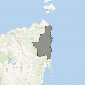
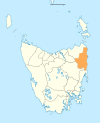
Map showing the Break O'Day local government area. | |||||||||||||||
| Coordinates | 41.4238°S 148.0524°E | ||||||||||||||
| Population | 6,232 (2018)[1] | ||||||||||||||
| • Density | 1.7/km2 (4.4/sq mi) | ||||||||||||||
| Established | 2 April 1993[2] | ||||||||||||||
| Area | 3,524 km2 (1,360.6 sq mi)[1] | ||||||||||||||
| Mayor | Mick Tucker | ||||||||||||||
| Council seat | St Helens | ||||||||||||||
| Region | Northern east coast | ||||||||||||||
| State electorate(s) | Lyons | ||||||||||||||
| Federal Division(s) | Lyons | ||||||||||||||
| Website | Break O'Day Council | ||||||||||||||
| |||||||||||||||
History and attributes
The municipality was established on 2 April 1993. Originally proclaimed as Portland-Fingal, the name was later changed to Break O'Day.[2]
Break O'Day is classified as rural, agricultural and large (RAL) under the Australian Classification of Local Governments.[3]
Council
Current composition and election method
Break O'Day Council is composed of nine Councillors elected using the Hare-Clark system of proportional representation as a single ward. All Councillors are elected for a fixed four-year term of office. The Mayor and Deputy Mayor are each directly elected for a four-year term. The Mayor and Deputy Mayor must also be elected as Councillors in order to hold office. Elections are normally held in October, with the next election due to be held in October 2022.[4] Neither the Labor Party nor the Liberal Party endorse local government candidates in Tasmania.
The most recent election of Councillors was held in October 2018, and the makeup of the Council is as follows:[5]
| Party | Councillors | |
|---|---|---|
| Independents and Unaligned | 9 | |
| Total | 9 | |
The current Council, elected in 2018 is:[5]
| Councillor | Party | Notes | |
|---|---|---|---|
| Mick Tucker | Independent | Mayor | |
| Lesa Whittaker | Independent | ||
| Glenn McGuinness | Unaligned | ||
| John McGiveron | Unaligned | Deputy Mayor | |
| Barry LeFevre | Independent | ||
| Margaret Osborne OAM | Unaligned | 1 | |
| Kristi Chapple | Unaligned | ||
| Kylie Wright | Independent | ||
| Janet Drummond | Unaligned | ||
- ^1 At the 2018 election, John Tucker was elected to Council. Following the resignation of John Tucker after being elected to state parliament, a recount was conducted and Margaret Osborne was elected as councillor until the 2022 ordinary election.
Suburbs
| Suburb | Census population 2016 | Reason |
|---|---|---|
| Mount William | 0 | |
| Eddystone | 0 | |
| Ansons Bay | 31 | |
| Lottah | 13 | |
| The Gardens | 19 | |
| Binalong Bay | 290 | |
| Akaroa | 132 | |
| Stieglitz | 562 | |
| Dianas Basin | Incl in St. Helens | |
| Beaumaris | 289 | |
| Scamander | 638 | |
| Upper Scamander | 44 | |
| Falmouth | 102 | |
| Four Mile Creek | 96 | |
| Chain of Lagoons | 21 | |
| Seymour | 25 | |
| Douglas River | 30 | |
| Ormley | Incl. in Fingal | |
| Tullochgorum | Incl. in Fingal | |
| Fingal | 405 | Includes Ormley, Tolluchgorum, Frodsley |
| Mount Nicholas | Incl. in St. Mary's | |
| Cornwall | 65 | |
| Cullenswood | Incl. in St. Mary's | |
| St. Mary's | 682 | Includes Mount Nicholas, Cullenswood |
| Gray | 69 | |
| Mathinna | 142 | |
| Upper Esk | 26 | Includes Roses Tier |
| Mangana | 36 | |
| Roses Tier | Incl. in Upper Esk | |
| Frodsley | Incl. in Fingal | |
| Weldborough | 28 | |
| Pyengana | 104 | |
| Goulds Country | 77 | |
| Goshen | 93 | |
| St. Helen's | 2070 | Includes Priory |
| Priory | Incl. in St. Helen's | |
| Total | 6,089 | |
| 15 | Variance | |
| Local government total | 6,104 | Gazetted Break O'Day Council Local Government Area |
Not in above list
See also
- List of local government areas of Tasmania
References
- "3218.0 – Regional Population Growth, Australia, 2017-18: Population Estimates by Local Government Area (ASGS 2018), 2017 to 2018". Australian Bureau of Statistics. Australian Bureau of Statistics. 27 March 2019. Retrieved 25 October 2019. Estimated resident population, 30 June 2018.
- "Agency Details: Break O'Day Municipal Council". search.archives.tas.gov.au. Tasmanian Government. Retrieved 11 June 2018.
- "Local government national report 2014-2015". regional.gov.au. Australian Government. Retrieved 8 June 2018.
- "Council: Elected Members". Your council. Break O'Day Council. Retrieved 12 August 2015.
- "Break O'Day Council". Local Government Elections 2014. Tasmanian Electoral Commission. 2014. Archived from the original on 24 September 2015. Retrieved 12 August 2015.
- Australian Bureau of Statistics. "2011 Census QuickStats". Retrieved 4 January 2018.
External links
- Break O'Day Council official website
- Local Government Association Tasmania
- Tasmanian Electoral Commission - local government
East Coast region of Tasmania, Australia | |||||
|---|---|---|---|---|---|
| Settlements | |||||
| Governance former | |||||
| Mountains | |||||
| Protected areas, parks and reserves | |||||
| Harbours, bays, inlets and estuaries | |||||
| Landmarks |
| ||||
| People of note | |||||
| Islands |
| ||||
| Books and newspapers | |||||
| Flora, fauna, and fishlife | |||||
| Bioregions | |||||
| |||||