Brazil–Colombia border
The border between Brazil and Colombia is 1,644.2 km (1,021.7 mi) long. The boundary was delimited in two treaties:
- the Vásquez Cobo-Martins treaty of 1907, establishing the line from the Rio Negro northwestward along the Amazon River-Orinoco watershed divide, "then generally southward along various river courses and straight-line segments to the mouth of the Apaporis River",[1] and
- the Tratado de Límites y Navegación Fluvial of 1928, delimiting the Apaporis-Amazon segment of the boundary as a "geodesic line identical to its Brazilian-Peruvian antecedent after Colombia gained undisputed sovereignty over the area".[1]
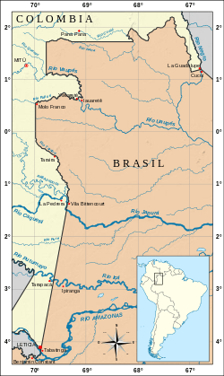
Map op the Brazil–Colombia border area
Border towns

gollark: That's the correct answer, though.
gollark: Also, consider the implications for code guessing of https://storage.googleapis.com/deepmind-media/AlphaCode/competition_level_code_generation_with_alphacode.pdf.
gollark: Of course they are. Which ones did *you* get?
gollark: Huh.
gollark: Wow, THAT'S what's in the file?
External links
References
- Brazil-Colombia boundary "Colombian Chancellery". 2006-09-16., International Boundary Study, April 15, 1985.
This article is issued from Wikipedia. The text is licensed under Creative Commons - Attribution - Sharealike. Additional terms may apply for the media files.