Brauro Cove
Brauro Cove (Bulgarian: Ивайлов залив, ‘Ivaylov Zaliv’ \i-'vay-lov 'za-liv\) is the 1.93 km wide cove indenting for 620 m the northwest coast of Snow Island in the South Shetland Islands, Antarctica. It is entered southwest of Mezdra Point and northeast of Irnik Point.[1]
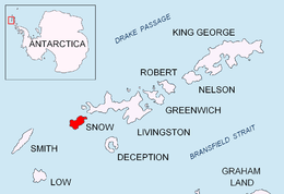
Location of Snow Island in the South Shetland Islands

Location
Brauro Cove is centred at 62°43′15″S 61°21′20″W. British mapping in 1968, Bulgarian in 2009 and 2017.
Maps
- Livingston Island to King George Island. Scale 1:200000. Admiralty Chart 1776. UK Hydrographic Office, 1968
- L.L. Ivanov. Antarctica: Livingston Island and Greenwich, Robert, Snow and Smith Islands. Scale 1:120000 topographic map. Troyan: Manfred Wörner Foundation, 2009. ISBN 978-954-92032-6-4
- L.L. Ivanov. Antarctica: Livingston Island and Smith Island. Scale 1:100000 topographic map. Manfred Wörner Foundation, 2017. ISBN 978-619-90008-3-0
- Antarctic Digital Database (ADD). Scale 1:250000 topographic map of Antarctica. Scientific Committee on Antarctic Research (SCAR). Since 1993, regularly upgraded and updated
Notes
- Brauro Cove. SCAR Composite Gazetteer of Antarctica
gollark: Anyway, the issue with making stuff mandatory at school and stuff is that it will often end up just making people learn how to run the algorithms and whatnot enough to pass exams rather than creating actual understanding and ability to solve practical problems.
gollark: Yes, apparently.
gollark: I don't know about in the US, but there is a *lot* of difference in earnings between courses.
gollark: The UK government has some interesting data from large-scale surveys on employment status of people after graduating from university.
gollark: I'm pointing out downsides to it.
References
- Brauro Cove. SCAR Composite Gazetteer of Antarctica
- Bulgarian Antarctic Gazetteer. Antarctic Place-names Commission. (details in Bulgarian, basic data in English)
External links
- Brauro Cove. Adjusted Copernix satellite image
This article includes information from the Antarctic Place-names Commission of Bulgaria which is used with permission.
This article is issued from Wikipedia. The text is licensed under Creative Commons - Attribution - Sharealike. Additional terms may apply for the media files.