Bradley Airport Connector
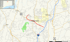
The Bradley Airport Connector (also the Bradley Field Connector) is a 4.6-mile (7.4 km) expressway built to connect Bradley International Airport to Interstate 91 in Windsor, Connecticut. It begins at Exit 40 of I-91 and heads west as Route 20 along the town line between Windsor and Windsor Locks. The expressway then turns north, leaving Route 20 and becoming an unsigned state road (with designation Special Service Road 401) ending at the airport terminals.
| Bradley Airport Connector | |
|---|---|
 Map of Hartford County in northern Connecticut with Bradley Airport Connector highlighted in red | |
| Route information | |
| Length | 4.59 mi (7.39 km) |
| Component highways | |
| Major junctions | |
| South end | |
| North end | Bradley International Airport in Windsor Locks |
| Location | |
| Counties | Hartford |
| Highway system | |
| |
On October 10, 1999, the Connector was named the "82nd Airborne Memorial Highway",[1] in honor of the U.S. Army's 82nd Airborne Division. According to the Connecticut Department of Transportation, the expressway carries as many as 54,900 vehicles per day (as of 2007).[2]
Route description
The highway begins at Exit 40 of I-91 in the town of Windsor. After traveling about a quarter of a mile along the exit ramp, the main roadway starts as a four-lane expressway with unnumbered exits. The highway's first exit is with Old County Road a mile later. The second exit is signed for Route 75, which provides access to the long-term parking lots of the airport and leads to the town of Suffield. After about 0.6 miles (0.97 km), the highway has another exit for Hamilton Road. Soon after this exit, Route 20 exits at the highway's fourth exit to continue on surface roads to East Granby. At this point, the expressway turns north to enter Windsor Locks and soon enters the perimeter of Bradley International Airport. After a partial interchange with Hamilton Road North, the highway ends at Schoephoester Road, a one-way road that connects to the terminal access road.
The highway designation becomes Special Service Road 401 (SSR 401) after Route 20 leaves the Connector. The SSR 401 designation continues east on Schoephoester Road, which continues for another 1.2 miles (1.9 km) as a four-lane surface road to connect with Route 75. Schoephoester Road also provides access to the Bradley Airport parking lots. The airport terminal access road connects to Schoephoester Road about half a mile east of the end of the expressway at a jughandle intersection. The airport terminal access road is a one-way, unsigned state road with designation Special Service Road 403 (SSR 403).
History
The project to build this connector was proposed in the early 1950s, but was not started until 1958. Three years later, on July 3, 1961, the four-lane expressway was open to traffic. The highway cost $3.9 million to construct. When the Connector opened to traffic, Route 20 was relocated to use the east–west portion of the highway. This resulted in Route 20 being truncated to end at I-91. The portion of the highway that is not part of Route 20 was assigned as SSR 401 in 1963.
Exit list
The entire route is in Hartford County. All exits are unnumbered.
| Location | mi | km | Destinations | Notes | |
|---|---|---|---|---|---|
| Windsor Locks–Windsor line | 31.30 | 50.37 | Exit 40 on I-91; eastern terminus of Route 20 | ||
| 30.30 | 48.76 | Old County Road / Kennedy Road | |||
| 29.01 | 46.69 | Access to Bradley International Airport long-term parking | |||
| 28.42 | 45.74 | Hamilton Road South | |||
| Windsor Locks–Windsor– East Granby tripoint | 28.11 | 45.24 | Route 20 exits freeway; SSR 401 begins at westbound exit ramp | ||
| Windsor Locks | Expressway ends; SSR 401 continues as a surface road to Route 75 | ||||
| Hamilton Road North | Former northbound exit and southbound entrance; permanently closed for highway realignment | ||||
1.000 mi = 1.609 km; 1.000 km = 0.621 mi
| |||||
References
- Connecticut General Assembly, Public Act 99-181, Sec. 31
- Connecticut Department of Transportation, 2007 traffic log