Bobritzsch (river)
The Bobritzsch is a river of Saxony, Germany. It is a right tributary of the Freiberger Mulde with a length of about 38 km (24 mi). Its Gewässerkennzahl is 5422.[3]
| Bobritzsch | |
|---|---|
 Salzbrücke across Bobritzsch between Falkenberg and Krummenhennersdorf | |
| Location | |
| Country | Germany |
| State | Saxony |
| Physical characteristics | |
| Source | |
| • location | near Reichenau |
| • coordinates | 50°46′56.4″N 13°35′59″E |
| • elevation | 674 m (NHN) |
| Mouth | |
• location | near Reinsberg |
• coordinates | 51°1′14″N 13°20′22″E |
• elevation | 235 m (NHN) |
| Length | 38 km (24 mi) |
| Basin size | 131 km2 (51 sq mi) |
| Discharge | |
| • location | Krummenhennersdorf |
| • average | 1.53 m3/s (54 cu ft/s) |
| • minimum | 66 l/s (16.08.2000)[1] |
| • maximum | 160 m3/s (5,700 cu ft/s) (13.08.2002)[2] |
| Basin features | |
| Progression | Freiberger Mulde→ Mulde→ Elbe→ North Sea |
Course
The source of the river is located about 5 km (3.1 mi) south-east of Frauenstein in the Eastern Ore Mountains, above Hartmannsdorf-Reichenau on the edge of Kreuzwald forest and 600 m (2,000 ft) from Weicheltmühle (a watermill) on Gimmlitz river.
The river passes through Reichenau, Kleinbobritzsch, Hartmannsdorf, Friedersdorf, Oberbobritzsch and Niederbobritzsch, Naundorf, Falkenberg, Krummenhennersdorf, Reinsberg and Bieberstein.
A well-known hiking path along Bobritzsch river between Krummenhennersdorf and Reinsberg is called Grabentour.[4] Reinsberg Castle is located on a rock above the right bank of the river, Bieberstein Castle above its left bank.
Bobritzsch river joins Freiberger Mulde between Reinsberg and Siebenlehn, 1 km (0.62 mi) north of Bieberstein castle.
Origin of the name
The name of the river originates from Old Sorbian Bobrica, derived from bobr (beaver), and signifies a water course where beavers lived.[5]
Gallery
 Between Oberbobritzsch and Niederbobritzsch
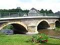 Bridge of Bundesstraße 173 in Naundorf
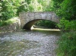
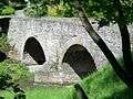 Arch bridge in Falkenberg, built in 1567
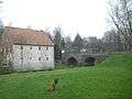 Former Erblehnmühle near the arch bridge
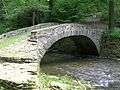 Schafbrücke ("sheep's bridge") near Oberschaar
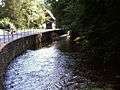
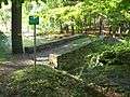 Flood level of August 2002 near Schafbrücke
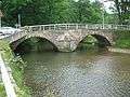 Bridge in Krummenhennersdorf, built in 1806
See also
References
- "Hydrologisches Handbuch: Teil 3 - Gewässerkundliche Hauptwerte" (PDF, 637 kB). Freistaat Sachsen - Landesamt für Umwelt und Geologie. p. 86. Retrieved 2012-10-04.
- Hochwasserschutz 2002 im Muldegebiet Sächsisches Landesamt für Umwelt, Landwirtschaft und Geologie; 2009 (PDF; 5,4)
- Hydrologisches Handbuch. Teil 2. Gebietskennzahlen. Landesamt für Umwelt, Landwirtschaft und Geologie. January 2002. Archived from the original on 2014-10-07. Retrieved 2016-07-07.
- "Grabentour von Krummenhennersdorf nach Reinsberg". Geo- und Umweltportal Freiberg. July 2004. Retrieved 2016-07-07.
- Robert Immisch (1866). Die slavischen Ortsnamen im Erzgebirge. Bautzen: Schmaler & Pech.