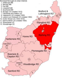
Blything Rural District
Blything Rural District was a rural district within the administrative county of East Suffolk between 1894 and 1934. It was created out of the earlier Blything rural sanitary district.[1]
| Blything | |
|---|---|
 Location within East Suffolk, 1894 | |
| History | |
| • Created | 1894 |
| • Abolished | 1934 |
| • Succeeded by | Blyth Rural District |
| Status | Rural district |
Two urban districts were subsequently created out of parishes within Blything: Leiston cum Sizewell UD in 1895 and Halesworth in 1900.
In 1934, under a County Review Order, Blything Rural District was abolished. The largest part of its territory passed to the new but similarly named Blyth Rural District; apart from small adjustments the rest went to Lothingland and Wainsford RDs.
Statistics
| Year | Area[2] | Population [3] |
Density (pop/ha) | |
|---|---|---|---|---|
| acres | ha | |||
| 1911 | 87,438 | 35,385 | 18,190 | 0.51 |
| 1921 | 17,896 | 0.51 | ||
| 1931 | 16,614 | 0.47 | ||
Parishes
| Parish | To | Notes |
|---|---|---|
| Aldringham cum Thorpe | 1934 | Detached. To Blyth RD |
| Benacre | 1934 | To Lothingland RD |
| Blyford | 1934 | To Wainford RD |
| Blythburgh | 1934 | To Blyth RD |
| Bramfield | 1934 | To Blyth RD |
| Brampton | 1934 | To Wainford RD |
| Chediston | 1934 | To Blyth RD |
| Cookley | 1934 | To Blyth RD |
| Covehithe | 1934 | To Lothingland RD |
| Cratfield | 1934 | To Blyth RD |
| Darsham | 1934 | To Blyth RD |
| Dunwich | 1934 | To Blyth RD (part to Southwold MB) |
| Easton Bavents | 1934 | To Lothingland RD (part to Southwold MB) |
| Frostenden | 1934 | To Lothingland RD |
| Halesworth | 1900 | To Halesworth UD |
| Henham | 1934 | To Lothingland RD |
| Henstead | 1934 | To Lothingland RD |
| Heveningham | 1934 | To Blyth RD |
| Holton | 1934 | To Wainford RD (part to Halesworth UD) |
| Huntingfield | 1934 | To Blyth RD |
| Kelsale cum Carlton | 1934 | To Blyth RD |
| Knodishall | 1934 | To Blyth RD |
| Leiston | 1895 | To Leiston cum Sizewell UD |
| Linstead Magna | 1934 | To Blyth RD |
| Linstead Parva | 1934 | To Blyth RD |
| Middleton | 1934 | To Blyth RD |
| Peasenhall | 1934 | To Blyth RD |
| Reydon | 1934 | To Lothingland RD |
| Rumburgh | 1934 | To Wainford RD |
| Sibton | 1934 | To Blyth RD |
| Sotherton | 1934 | To Wainford RD |
| South Cove | 1934 | To Lothingland RD |
| Spexhall | 1934 | To Wainford RD |
| Stoven | 1934 | To Wainford RD |
| Theberton | 1934 | To Blyth RD (part to Leiston-cum-Sizewell UD) |
| Thorington | 1934 | To Blyth RD |
| Ubbeston | 1934 | To Blyth RD |
| Uggeshall | 1934 | To Lothingland RD |
| Walberswick | 1934 | To Blyth RD (part to Southwold MB) |
| Walpole | 1934 | To Blyth RD |
| Wangford | 1934 | To Lothingland RD |
| Wenhaston | 1934 | To Blyth RD |
| Westhall | 1934 | To Wainford RD |
| Westleton | 1934 | To Blyth RD |
| Wissett | 1934 | To Wainford RD (part to Halesworth UD) |
| Wrentham | 1934 | To Lothingland RD |
| Yoxford | 1934 | To Blyth RD |
gollark: Fine.
gollark: [REDACTED]
gollark: What if I disguise the sheep as bees?
gollark: Well, the bees are going past the perimeter, actually.
gollark: I may have to somehow disguise the sheep as bees then!
References
- "Blything RD through time: Census tables with data for the Local Government District". A Vision of Britain through Time. GB Historical GIS / University of Portsmouth. Retrieved 9 July 2017.
- "Blything RD through time: Population Statistics: Area (acres)". A Vision of Britain through Time. GB Historical GIS / University of Portsmouth. Retrieved 9 July 2017.
- "Blything RD through time: Population Statistics: Total Population". A Vision of Britain through Time. GB Historical GIS / University of Portsmouth. Retrieved 9 July 2017.
This article is issued from Wikipedia. The text is licensed under Creative Commons - Attribution - Sharealike. Additional terms may apply for the media files.