Bistrița (Olt)
Bistrița (Romanian pronunciation: [ˈbistrit͡sa] (![]()
| Bistrița Bistrița Vâlceană | |
|---|---|
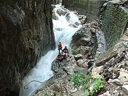 View of the Bistrița Valley | |
| Location | |
| Country | Romania |
| Counties | Vâlcea County |
| Physical characteristics | |
| Mouth | Olt |
• location | Băbeni |
• coordinates | 44.9656°N 24.2721°E |
| Length | 50 km (31 mi) |
| Basin size | 355 km2 (137 sq mi) |
| Basin features | |
| Progression | Olt→ Danube→ Black Sea |
Tributaries
The following rivers are tributaries of the river Bistrița (from source to mouth):[2]
- Left: Costești, Otăsău
- Right: Valea Rece, Cuca, Gurgui, Bistricioara, Iazul Morților
gollark: To make fuels you need reactors burning lesser fuels.
gollark: Anyway, it may not ever happen, as my todo list's length can only be expressed as the size of the set of all real numbers.
gollark: That would depend on how lazy I would be when making it.
gollark: The idea is that you could run the hypothetical web planner in the browser, and even conveniently share design links with people.
gollark: It's like cars, and how they are different to carpets.
References
- "Planul național de management. Sinteza planurilor de management la nivel de bazine/spații hidrografice, anexa 7.1" (PDF, 5.1 MB). Administrația Națională Apele Române. 2010. p. 714.
- Atlasul cadastrului apelor din România. Partea 1 (in Romanian). Bucharest: Ministerul Mediului. 1992. pp. 297–298. OCLC 895459847. River code: VIII.1.150
- Plan de apărare în cazul producerii unei situații de urgență specifice (seisme și/sau alunecări de teren) al comitetul județean pentru situații de urgență Vâlcea, p. 91 (in Romanian)
- Apele județului la control – Monitorul de Vâlcea Nr. 2023 – 23 aprilie 2008
- Trasee turistice – județul Vâlcea
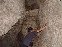
"Liliecilor" cave
This article is issued from Wikipedia. The text is licensed under Creative Commons - Attribution - Sharealike. Additional terms may apply for the media files.