Bicaz (river)
The Bicaz (Hungarian: Békás-patak) is a right tributary of the river Bistrița in Romania.[1][2] Its source is in the Hășmaș Mountains. Its uppermost course, upstream from Red Lake (Lacul Roșu), is also called Vereșchiu. Other tributaries of Lacul Roșu are Pârâul Oii (Oaia), Licoș and Suhard.[3] It discharges into the Bistrița in Bicaz. The Romanian name derives from the Hungarian name, which means literally frog-rivulet (hun.: béka = frog). Its length is 39 km (24 mi) and its basin size is 566 km2 (219 sq mi).[2]
| Bicaz | |
|---|---|
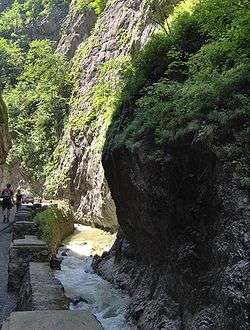 View of the Bicaz Gorges | |
| Location | |
| Country | Romania |
| Counties | Harghita, Neamț |
| Villages | Lacu Roșu, Bicaz-Chei, Bicazu Ardelean, Tașca |
| Physical characteristics | |
| Source | Hășmaș Mountains |
| Mouth | Bistrița |
• location | Bicaz |
• coordinates | 46.9116°N 26.0918°E |
| Length | 39 km (24 mi) |
| Basin size | 566 km2 (219 sq mi) |
| Basin features | |
| Progression | Bistrița→ Siret→ Danube→ Black Sea |
The main tributaries of the river are:[2]
References
- "Planul național de management. Sinteza planurilor de management la nivel de bazine/spații hidrografice, anexa 7.1" (PDF, 5.1 MB). Administrația Națională Apele Române. 2010. pp. 911–912.
- Atlasul cadastrului apelor din România. Partea 1 (in Romanian). Bucharest: Ministerul Mediului. 1992. pp. 395–396. OCLC 895459847. River code: XII.1.53.48
- Morphometrical characteristics of Red Lake river bain, A. Enea, G. Romanescu and C. Stoleriu
This article is issued from Wikipedia. The text is licensed under Creative Commons - Attribution - Sharealike. Additional terms may apply for the media files.