Benjamin Banneker: SW-9 Intermediate Boundary Stone
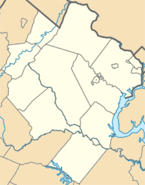
Benjamin Banneker: SW 9 Intermediate Boundary Stone, also known as an Intermediate Stone of the District of Columbia, is a surveyors' boundary marker stone. The stone is located on the original boundary of the District of Columbia (see: Boundary markers of the original District of Columbia and History of Washington, D.C.) The stone is now on the boundary of Arlington County, Virginia and the City of Falls Church. It is within the two jurisdiction's Benjamin Banneker Park at 6620 18th Street North, Arlington.[3][4]
Benjamin Banneker: SW 9 Intermediate Boundary Stone | |
SW9 Boundary Stone (2012) | |
   | |
| Location | 18th and Van Buren Sts., Arlington and Falls Church, Virginia |
|---|---|
| Coordinates | 38°52′58.6″N 77°9′32.6″W |
| Built | 1792 |
| NRHP reference No. | 76002094 |
| Significant dates | |
| Added to NRHP | May 11, 1976[1] |
| Designated NHL | May 11, 1976[2] |
The marker stone was named and declared a National Historic Landmark in 1976 at the instigation of the Afro-American Bicentennial Corporation. The name of the marker honors Benjamin Banneker, a free African American astronomer who in 1792 assisted in the early part of the survey that established the original boundaries of the District of Columbia.[1][2][5] The stone was the first of the District of Columbia boundary markers to be listed on the National Register of Historic Places.
Description and history

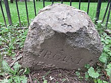
The boundary stone is a sandstone block about 1 foot (0.30 m) square in cross section, extending about 15 inches (38 cm) above ground and probably about 2 feet (0.61 m) below ground.[5] The top is rounded and worn.[5] Standardized inscriptions placed on each side of the stone are only partially visible, due in part to the stone's sinking over time.[3][5]
The words "Jurisdiction of the United States" are inscribed on the northeast side, which faced the federal territory (once the District of Columbia; now Arlington County). The opposite side now facing the City of Falls Church contains the remnant of the word "Virginia". Between those two sides, one side contains the year "1791", while the opposite side contains the remnant of an inscription recording the variation of the compass needle at the stone's location (indicated as "Var.").[6] A brass marker was once mounted top of the stone, placed in early 1900s by the Daughters of the American Revolution; it has since been removed.[5]
Benjamin Banneker (1731-1806) was a free African American mathematician and astronomer who assisted Andrew Ellicott during the first three months of the 1792 — 1793 survey of the District of Columbia's original boundaries.[7] The stone is one of 40 markers that once lined the District's boundaries.[3][4] Banneker had left the survey before Ellicott's team laid this and most of the other boundary marker stones.[8]
See also
References
- (1) "SW-9 Intermediate Boundary Stone (milestone) of the District of Columbia". NPGallery Digital Asset Management System. National Park Service. Retrieved 2019-04-20.
(2) "Benjamin Banneker: SW 9 Intermediate Boundary Stone". VIRGINIA - Arlington County. National Register of Historic Places.com. p. 1. Archived from the original on July 21, 2010. Retrieved 2013-01-05.
(3) "Benjamin Banneker. SW-9 Intermediate Boundary Stone (United States Department of the Interior: National Park Service: Annual Listing of Historic Properties: National Park Service: Notices)" (PDF). Federal Register. National Archives. 24 (26, Part 2): 7612. 1979-02-06.Virginia ... Arlington. BENJAMIN BANNEKER. SW-9 INTERMEDIATE BOUNDARY STONE, 18th and Van Buren Sts., N., (5-11-76) NHL
- "Banneker (Benjamin) SW-9 Intermediate Boundary Stone". National Historic Landmarks Program. National Park Service. Archived from the original on 2015-05-01. Retrieved 2017-01-29.
- "The Banneker Stone (SW #9)". The Boundary Stones Project. Falls Church Chapter of the Daughters of the American Revolution. 2017-10-11. Archived from the original on 2017-10-11. Retrieved 2017-06-01.
- "Benjamin Banneker Park". Department of Parks and Recreation, Arlington County, Virginia. Archived from the original on 2017-10-10. Retrieved 2017-10-10.
- Graves, Lynne Gomez, Historical Projects Director, Afro-American Bicentennial Corporation, Washington, D.C (1976-02-03). "Benjamin Banneker: SW-9 Intermediate Boundary Stone (milestone) of the District of Columbia" (PDF). United States Department of the Interior: National Park Service: National Register of Historic Places Inventory––Nomination Form. Richmond, Virginia: Virginia Department of Historic Resources. Archived from the original (PDF) on 2019-04-20. Retrieved 2019-04-20. and "Accompanying three photos (undated)". Archived from the original on 2019-04-20.
- (1) National Capital Planning Commission (1976). Boundary markers of the Nation's Capital: a proposal for their preservation & protection : a National Capital Planning Commission Bicentennial report. Washington, D.C.: National Capital Planning Commission; For sale by the Superintendent of Documents, United States Government Printing Office. p. 9. OCLC 3772302. Retrieved 2016-02-22. At HathiTrust Digital Library
(2) "SW9". Boundary Stones of the District of Columbia. boundarystones.org. Archived from the original on 2016-10-15. Retrieved 2017-01-29. - (1) Bedini, Silvio A. (1999). The Life of Benjamin Banneker: The First African-American Man of Science (2nd ed.). Baltimore: Maryland Historical Society. ISBN 0-938420-59-3. LCCN 98022848. OCLC 39024784. Retrieved 2017-05-31 – via Internet Archive.
(2) Bedini, Silvio A. (2008). "Banneker, Benjamin". Complete Dictionary of Scientific Biography. Charles Scribner's Sons. Archived from the original on 2018-02-23. Retrieved 2018-02-23 – via Encyclopedia.com. - Boyd, Julian P., ed. (1974). Locating the Federal District: Editorial Note: Footnote number 119. The Papers of Thomas Jefferson: 24 January–31 March 1791. 19. Princeton, New Jersey: Princeton University Press. pp. 41–43. ISBN 9780691185255. LCCN 50007486. OCLC 1045069058. Retrieved 2019-03-27 – via Google Books.
Recent biographical accounts of Benjamin Banneker (1731–1806), a mulatto whose father was a native African and whose grandmother was English, have done his memory a disservice by obscuring his real achievements under a cloud of extravagant claims to scientific accomplishment that have no foundation in fact. The single notable exception is Silvio A. Bedini’s The Life of Benjamin Banneker (New York, 1972), a work of painstaking research and scrupulous attention to accuracy which also benefits from the author’s discovery of important and hitherto unavailable manuscript sources. However, as Bedini points out, the story of Banneker’s involvement in the survey of the Federal District “rests on extremely meager documentation” (p. 104). This consists of a single mention by TJ, two brief statements by Banneker himself, and the newspaper allusion quoted above. In consequence, Bedini’s otherwise reliable biography accepts the version of Banneker’s role in this episode as presented in reminiscences of nineteenth-century authors. These recollections, deriving in large part from members of the Ellicott family, who were prompted by Quaker inclinations to justice and equality, have compounded the confusion. The nature of TJ’s connection with Banneker is treated in the Editorial Note to the group of documents under 30 Aug. 1791, but because of the obscured record it is necessary here to attempt a clarification of the role of this modest, self-taught tobacco farmer in the laying out of the national capital.
First of all, because of unwarranted claims to the contrary, it must be pointed out that there is no evidence whatever that Banneker had anything to do with the survey of the Federal City or indeed with the final establishment of the boundaries of the Federal District. All available testimony shows that he was present only during the few weeks early in 1791 when the rough preliminary survey of the ten mile square was made; that, after this was concluded and before the final survey was begun, he returned to his farm and his astronomical studies in April, accompanying Ellicott part way on his brief journey back to Philadelphia; and that thenceforth he had no connection with the mapping of the seat of government. ...
In any case, Banneker’s participation in the surveying of the Federal District was unquestionably brief and his role uncertain.
| Wikimedia Commons has media related to Boundary Stone (District of Columbia) SW 9. |