Bengal, Missouri
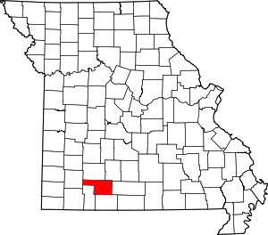
Bengal was an unincorporated community in Christian County, in the U.S. state of Missouri.[1] It was located along Tory Creek about one mile upstream (south) of Montague along the road to Ponce de Leon which is approximately three miles to the southwest. Spokane was about 2.5 miles to the south-southeast.[2] The location is within South Galloway Township.[3] The elevation of Bengal is 1,243 feet.[1]
History
A post office called Bengal was established in 1897, and remained in operation until 1918.[4] The origin of the name Bengal is obscure.[5]
gollark: https://www.smbc-comics.com/comics/1601566516-20201001.png
gollark: You can also launch a denial of service attack by unplugging the power or coaxial/phone/ethernet cable.
gollark: I was just explaining for foolish apioids who do NOT know that.
gollark: * composed purely of horrendously apiaristic forms
gollark: My router's web interface sends some sort of horrible XPath RPC stuff *in JSON* *in a form body* to a backend which then sends back some weird JSON looking like this, which is, I think, a general indication of its code quality.
References
- U.S. Geological Survey Geographic Names Information System: Bengal, Missouri
- Forsyth, MO, 1:125000 scale Topographic Map, USGS, 1907
- "Bengal Populated Place Profile / Christian County, Missouri Data". missouri.hometownlocator.com. Retrieved 2017-03-11.
- "Post Offices". Jim Forte Postal History. Archived from the original on 6 March 2016. Retrieved 18 September 2016.
- "Christian County Place Names, 1928–1945 (archived)". The State Historical Society of Missouri. Archived from the original on 24 June 2016. Retrieved 18 September 2016.CS1 maint: BOT: original-url status unknown (link)
This article is issued from Wikipedia. The text is licensed under Creative Commons - Attribution - Sharealike. Additional terms may apply for the media files.
