Belar, New South Wales
Yarrawin, New South Wales is a bounded rural locality of the Warrumbungle Shire and a civil parish of Gowen County, New South Wales.[1][2]
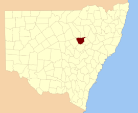
Gowen NSW.
Location
The parish is on the Castlereagh River,[3] between Coonabarabran and Binnaway, New South Wales.
gollark: Actually, GTech™ is able to exchange capital for senses of accomplishment bidirectionally.
gollark: Yes.
gollark: But the sense of accomplishment?!
gollark: Wow, I do love vendor lockin and probably Google spying.
gollark: It's better than the unreliable gevent hacks it used.
References
- Robert McLean, The New atlas of Australia : the complete work containing over one hundred maps and full descriptive geography of New South Wales, Victoria, Queensland, South Australia and Western Australia, together with numerous illustrations and copious indices (Sydney :John Sands, [1886) Map 14.
- Map of Gowan County, New South Wales.
- Robert McLean, The New atlas of Australia : the complete work containing over one hundred maps and full descriptive geography of New South Wales, Victoria, Queensland, South Australia and Western Australia, together with numerous illustrations and copious indices (Sydney :J. Sands, [1886) Map 14.
This article is issued from Wikipedia. The text is licensed under Creative Commons - Attribution - Sharealike. Additional terms may apply for the media files.