Belalie East, South Australia
Belalie East is a rural locality in the Mid North region of South Australia. It is situated in the Northern Areas Council.[1] The boundaries were formally established in April 2001 for the long established local name, relating to the cadastral Hundred of Belalie; however, the modern locality is divided between Belalie and the adjacent Hundred of Whyte.[2]
| Belalie East South Australia | |||||||||||||||
|---|---|---|---|---|---|---|---|---|---|---|---|---|---|---|---|
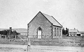 Former Presbyterian Church in 1910 | |||||||||||||||
 Belalie East | |||||||||||||||
| Coordinates | [1] | ||||||||||||||
| Postcode(s) | 5491 [1] | ||||||||||||||
| LGA(s) | Northern Areas Council [1] | ||||||||||||||
| State electorate(s) | Stuart [1] | ||||||||||||||
| Federal Division(s) | Grey [1] | ||||||||||||||
| |||||||||||||||
| Footnotes | Adjoining localities[1] | ||||||||||||||
The Wilkins Highway runs roughly diagonally through the centre of Belalie East, connecting Jamestown and Hallett.[2]
The Belalie East school opened in 1878 and closed in 1959.[3] The Belalie East Memorial Hall opened on 1 September 1923, and survives today.[3][4] A Presbyterian church was built in 1881; its date of closure is unknown.[5] It also formerly had its own coursing club.[6] Belalie East has had three post offices: the first operated between 11 June 1873 and 2 May 1876, the second operated between 1 November 1883 and 31 March 1892 and the third operated between approximately 1896 and 1898.[7][8][9]
The historic Coolootoo Shepherd's Hut, a remnant of the significant Old Canowie Station, is located on the boundary between Belalie East and its southern neighbour Mayfield, and is listed on the South Australian Heritage Register.[10]
References
- "Search result(s) for Belalie East, 5491". Location SA Map Viewer. Government of South Australia. Retrieved 3 April 2016.
- "Search result(s) for Belalie East, 5491". Property Location Browser. Government of South Australia. Archived from the original on 12 October 2016. Retrieved 3 April 2016.
- "Place Names of South Australia - B". State Library of South Australia. Archived from the original on 8 March 2016. Retrieved 3 April 2016.
- "Minutes of the Special Meeting of the Northern Areas Council held in the Council Chamber 94 Ayr Street, Jamestown on Monday 13 July 2015" (PDF). Archived from the original (PDF) on 4 March 2016. Retrieved 3 April 2016.
- "A FAITHFUL PASTORATE". Christian Colonist. III (126). South Australia. 4 March 1881. p. 2. Retrieved 4 April 2016 – via National Library of Australia.
- "Death Of Mr. Ben Williams". The Advertiser (Adelaide). 95 (29, 395). South Australia. 29 December 1952. p. 7. Retrieved 4 April 2016 – via National Library of Australia.
- "Belalie East (1)". Post Office Reference. Premier Postal. Retrieved 3 April 2016.
- "Belalie East (2)". Post Office Reference. Premier Postal. Retrieved 3 April 2016.
- "Belalie East (3)". Post Office Reference. Premier Postal. Retrieved 3 April 2016.
- "Coolootoo Shepherd's Hut". South Australian Heritage Register. Department of Environment, Water and Natural Resources. Retrieved 3 April 2016.