Beinn a' Chroin
Beinn a’ Chroin is a Scottish mountain located six kilometres south of Crianlarich in the Stirling Council area. With a height of 942 metres (3,091 feet) it qualifies as a Munro.
| Beinn a’ Chroin | |
|---|---|
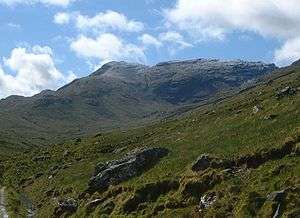 Beinn a‘ Chroin seen from upper Glen Falloch. | |
| Highest point | |
| Elevation | 942 m (3,091 ft) [1] |
| Prominence | 137 m (449 ft) |
| Listing | Munro |
| Naming | |
| English translation | Hill Of The Sheepfold |
| Language of name | Scottish Gaelic |
| Pronunciation | Gaelic [peɲ əˈxɾɔɲ] ( |
| Geography | |
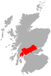
| Location | Stirlingshire, Scotland |
| Parent range | Grampians |
| OS grid | NN387185 |
| Topo map | OS Landranger 50, 56 OS Explorer 364 |
| Listed summits of Beinn a' Chroin | ||||
| Name | Grid ref | Height | Status | |
|---|---|---|---|---|
| West top | NN387185 | 942 m (3090 ft) | Munro Summit | |
| East Top | NN394186 | 940 m (3084 ft) | Munro Top | |
Overview
Beinn a’ Chroin stands well into the interior of the Crianlarich group of seven munros and so it is usually climbed with other hills in the area, more often than not it is ascended with An Caisteal[2] which lies 1.5 kilometres to the north west across the Bealach Buidhe (805 metres). The hill is well seen from the upper part of Glen Falloch from where the long summit ridge and the steep head wall of Coire Earb can be appreciated. The translation of the mountains name from the Gaelic language is vague and there are three possible meanings. Some sources give the translation as “Hill of Danger”[3] although Beinn a’ Chroin is no more dangerous than any other peak in the group. Other sources give the meaning as “Hill of the Sheep Fold”[4] while others give it as “Hill of the Cloven Hoof”[5] referring to the mountains twin summits.
Geography
Beinn a’ Chroin's summit 'moved' in the 1990s. It has a 1.2 kilometre long summit ridge, two thirds to the west gently undulating with four tops and then one third with a distinct top at the eastern end, of the ridge separated by a col with a height of 877 metres. The recognised summit location of highest point of Beinn a’ Chroin changed in 1998. For all years prior, the official highest point of the mountain was the eastern end 940 metres. OS Landranger 1.50k map only showed a 938m spot height on western ridge. However autumn 1997 amateur cartographic sleuth Charles Everett noticed on the new OS 1.25k map, two small 940 metre contour rings without spot heights, on the western ridge, just 75 metres apart, one to NE one to SW. Realizing that these both had to be higher than the eastern top, he sent a number of letters to the Ordnance Survey over next six months asking for: firstly, the exact heights inside these contour rings, and secondly, why these two points, both of which were clearly higher points on the mountain than the eastern 940m top, hadn’t had spot heights detailed on the map. Initial response from some departments was unhelpful and frustrating and stating they were unable to give any information. Persistence with another couple of letters eventually hit the jackpot with a July 8, 1998 letter confirming that there was a spot height of 941.5m in one of the contour rings, but frustratingly not specifying which. Subsequently Harveys maps, when they republished their Crianlarich map, gave the NE contour ring on west ridge, 941m at 388186 and SW one 942m at 387185 representing the new summit position of Beinn a’Chroin. The eastern top has now become a subsidiary Munro “top” at 940 metres.
Beinn a’ Chroin is surrounded by four other Munros which lie round the head waters of the River Falloch, to the north and east lies Cruach Ardrain and Beinn Tulaichean which can be reached by an arduous journey contouring round Coire Earb and climbing the subsidiary top of Stob Glas. The other two Munros, An Caisteal and Beinn Chabhair can be attained by following the west ridge down to the Beallach Buidhe from here the continuation to An Caisteal is up steep slopes to the north west. To reach Beinn Chabhair there is further descending to the west to reach an unnamed col (609 metres) before ascending to the summit. The impressive Coire Earb stands on the north side of the mountain, this corrie gives fine examples of boulder fields and moraine as a result of glacial action from the last Ice age.[6] The smaller Coire a’ Chroin lies on the upper southern slopes and contains the small Lochan a’ Chroin. Drainage from the mountain reaches both coasts of Scotland with the River Falloch going west from Coire Earb to the Firth of Clyde while all other rainfall goes east to the Firth of Forth.
Ascents and summit
Most guide books recommend climbing Beinn a’ Chroin along with the adjacent Munro of An Caisteal. This walk starts from the A82 road at grid reference NN369239 and climbs An Caisteal first before continuing onto Beinn a’ Chroin by the Beallach Buidhe. A direct ascent is possible from the same starting point by walking high up into Coire Earb and then climbing the mountain by the north ridge which leads to the eastern end of the summit ridge.[7] The mountain can also be climbed from the east starting at the end of the public road which leads to Inverlochlarig from the A84 at grid reference NN445184. This route follows the track by the River Larig to reach the foot of the mountain before climbing it by its steep grassy south east slopes. The summit ridge is undulating with several strange rock formation and some small sheets of water around the highest point.[8]
References and footnotes
| Wikimedia Commons has media related to Beinn a' Chroin. |
- The Munros, Scottish Mountaineering Trust, 1986, Donald Bennett (Editor) ISBN 0-907521-13-4
- The High Mountains of Britain and Ireland, Diadem, 1993, Irvine Butterfield, ISBN 0-906371-30-9
- Hamish’s Mountain Walk, Baton Wicks, 1996, Hamish Brown, ISBN 1-898573-08-5
- The Munro - Scotlands Highest Mountains, 2006, Cameron McNeish, ISBN 1-84204-082-0
- 100 Best Routes on Scottish Mountains, Warner Books, 1992, Ralph Storer, ISBN 0-7515-0300-2
- Footnotes
- "walkhighlands Beinn a'Chroin". walkhighlands.co.uk. 2013. Retrieved 15 October 2013.
- "The Munros" Pages 13 (Gives route with An Caisteal).
- "100 Best Routes on Scottish Mountains" Pages 30 Gives translation as "Hill of Danger".
- visitscotland.com. Gives translation as "Hill of the Sheepfold".
- "Hamish‘s Mountain Walk" Pages 93 Gives translation as "Hill of the Cloven Hoof".
- Golledge, Nicholas R. (2007). "An ice cap landsystem for palaeoglaciological reconstructions: characterizing the Younger Dryas in western Scotland" (PDF). Quaternary Science Reviews. 26 (1–2): 213–229. doi:10.1016/j.quascirev.2006.08.007. Gives ice age info on Coire Earb.
- www.munromagic.com. Gives direct route up Coire Earb.
- "The Munros" Pages 13 Gives route from Inverlochlarig.
 |
|  | |
List of Munros | |||