Beeding Hill to Newtimber Hill
Beeding Hill to Newtimber Hill is a 321-hectare (790-acre) biological and geological Site of Special Scientific Interest north of Shoreham-by-Sea in West Sussex.[1][2] It is a Nature Conservation Review site, Grade 2,[3] and it includes Devil's Dyke Geological Conservation Review site.[4][5]
| Site of Special Scientific Interest | |
 | |
| Area of Search | West Sussex |
|---|---|
| Grid reference | TQ 250 112[1] |
| Interest | Biological Geological |
| Area | 321.0 hectares (793 acres)[1] |
| Notification | 1986[1] |
| Location map | [TQ 250 112 Magic Map] |
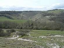
Most of this site on the slope of the South Downs is unimproved chalk grassland, which has a diverse flora with around 40 flowering plants per square metre. Invertebrates include a nationally important assemblage of harvestmen. Devil's Dyke is geologically important as an example of Pleistocene erosion of a dry chalk valley.[6]
References
- "Designated Sites View: Beeding Hill to Newtimber Hill". Sites of Special Scientific Interest. Natural England. Retrieved 18 April 2019.
- "Map of Beeding Hill to Newtimber Hill". Sites of Special Scientific Interest. Natural England. Retrieved 18 April 2019.
- Ratcliffe, Derek, ed. (1977). A Nature Conservation Review. 2. Cambridge, UK: Cambridge University Press. p. 120. ISBN 0521 21403 3.
- "Devil`s Dyke (Quaternary of South-East England)". Geological Conservation Review. Joint Nature Conservation Committee. Retrieved 5 April 2019.
- "Devil's Dyke (Karst)". Geological Conservation Review. Joint Nature Conservation Committee. Retrieved 5 April 2019.
- "Beeding Hill to Newtimber Hill citation" (PDF). Sites of Special Scientific Interest. Natural England. Retrieved 18 April 2019.
| Wikimedia Commons has media related to Beeding Hill to Newtimber Hill. |
This article is issued from Wikipedia. The text is licensed under Creative Commons - Attribution - Sharealike. Additional terms may apply for the media files.