Baring Head / Ōrua-pouanui
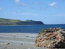
Baring Head / Ōrua-pouanui lies between Wellington Harbour and Palliser Bay at the southern end of the North Island of New Zealand.[1] The Baring Head Lighthouse, constructed in 1935, is located on the headland. It marks the southern end of Fitzroy Bay.
Biodiversity
At least nine "Nationally Threatened" or "At Risk" bird species are found at Baring Head / Ōrua-pouanui. These include the black shag, Caspian tern, New Zealand pipit, pied shag, pied stilt, red-billed gull, variable oystercatcher, white-fronted tern and the banded dotterel. The banded dotterel has a breeding site at Baring Head.[2] Baring Head / Ōrua-pouanui falls within the Wellington region's “coastal habitats of significance for indigenous birds”.[2]
Park
As part of a consortium, the Greater Wellington Regional Council purchased a 284.6 hectare property near the Baring Head lighthouse in June 2010 for addition to the East Harbour Regional Park. The purchase was made with financial contributions from the New Zealand Government's Nature Heritage Fund, Department of Conservation, Hutt City Council and a private benefactor. The purchase will protect a wide range of landscape, scientific, historical, ecological, cultural and recreational values. The area was opened to the general public on 13 February 2011.
A community group, the Friends of Baring Head, was formed in December 2010 to help the Regional Council in its management of the property.
Within the park is a set of natural rock formations which are used for rock climbing, specifically bouldering. Climbing website ClimbNZ describes this area as "the birthplace of bouldering in New Zealand" and list over 200 climbing routes on the rocks.[3]
Carbon dioxide monitoring
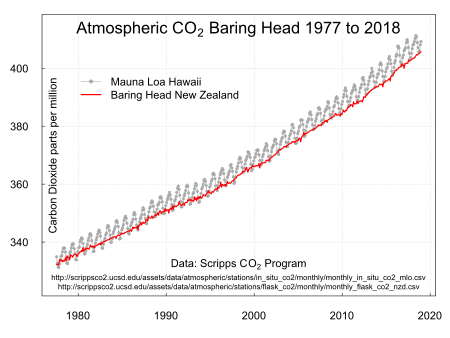
Atmospheric carbon dioxide monitoring is carried out at Baring Head.[4] The Carbon Dioxide Information Analysis Center in the United States has a record of measurements from 1970 to 1993[5] and from 1977 to December 2007.[6]
See also
External links
References
- Bradley, Barry (1999). New Zealand Atlas. Auckland, NZ: Penguin Books. ISBN 0-14-028914-3.
- McArthur, Nikki; Ray, Samantha; Crowe, Patrick; Bell, Mike (20 August 2019). A baseline survey of the indigenous bird values of the Wellington region coastline (PDF). Wildlife Management International. p. 43.
- "Baring Head | ClimbNZ | climbnz.org.nz". climbnz.org.nz. Retrieved 28 April 2020.
- MacManus, Joel (21 September 2019). "Dave Lowe found measurable proof of climate change 50 years ago - he's watched in horror ever since". Stuff. Retrieved 21 September 2019.
- Manning, M.R., A.J. Gomez, and K.P. Pohl. 1994. Atmospheric CO2 record from in situ measurements at Baring Head. Archived 31 May 2010 at the Wayback Machine In Trends: A Compendium of Data on Global Change. Carbon Dioxide Information Analysis Center, Oak Ridge National Laboratory, U.S. Department of Energy, Oak Ridge, Tenn., U.S.A.
- Keeling, R.F., S.C. Piper, A.F. Bollenbacher and J.S. Walker. 2008. Atmospheric Carbon Dioxide Record from Baring Head New Zealand, Archived 28 May 2010 at the Wayback Machine Atmospheric CO2 records from sites in the SIO air sampling network. In Trends: A Compendium of Data on Global Change. Carbon Dioxide Information Analysis Center, Oak Ridge National Laboratory, U.S. Department of Energy, Oak Ridge, Tenn., U.S.A.