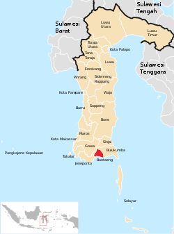
Bantaeng Regency
Bantaeng Regency (Kabupaten Bantaeng; ᨀᨅᨘᨄᨈᨙ ᨅᨈᨕᨙᨂ) is a regency of South Sulawesi, Indonesia. The administrative centre is the town of Bantaeng (historically, Bonthain), which lies on the south coast of the southern peninsula of Sulawesi island.
Bantaeng Regency Kabupaten Bantaeng ᨀᨅᨘᨄᨈᨙ ᨅᨈᨕᨙᨂ | |
|---|---|
 Seal | |
 | |
| Country | Indonesia |
| Province | South Sulawesi |
| Capital | Bantaeng |
| Government | |
| • Bupati | Dr.HM. Nurdin Abdullah M.Agr |
| Area | |
| • Total | 395.83 km2 (152.83 sq mi) |
| Population (2010 Census) | |
| • Total | 176,984 |
| • Density | 450/km2 (1,200/sq mi) |
| Time zone | UTC+8 (WITA) |
| Website | http://www.bantaeng.go.id |
Administration
Bantaeng Regency is divided into eight Districts (Kecamatan), tabulated below with their 2010 Census population.[1]
| Name | Population Census 2010 |
|---|---|
| Bissappu | 30,931 |
| Uluere | 10,814 |
| Sinoa | 11,827 |
| Bantaeng | 36,718 |
| Eremerasa | 18,614 |
| Tompobulu | 22,913 |
| Pa'jukukang | 29,017 |
| Gantarangkeke | 15,865 |
Beaches
Bantaeng Regency has 3 beaches:[2]
- Lamalaka Beach
- Seruni Beach
- Marina Beach and Resort
The previous 2 beaches is near the administrative centre, Bantaeng, and the last beach is 18 kilometers southeast of Lamalaka Beach.
gollark: You could just make the function contain... its argument names and content, surely?
gollark: (number)
gollark: 1.0000000004
gollark: Wait, is this just osmarkslisp™ with slightly different brackets?
gollark: `let` good, as they say.
References
- Biro Pusat Statistik, Jakarta, 2011.
- "Bantaeng". July 1, 2012. Archived from the original on 2012-10-05.
This article is issued from Wikipedia. The text is licensed under Creative Commons - Attribution - Sharealike. Additional terms may apply for the media files.
