Banská Štiavnica District
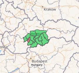
Banská Štiavnica District (okres Banská Štiavnica) is a district in the Banská Bystrica Region of central Slovakia. Until 1918, most of the present-day district belonged to the county of Kingdom of Hungary of Hont, apart from Močiar and Podhorie in the north (Tekov) and Kozelník in the east (Zvolen county).
Banská Štiavnica District | |
|---|---|
| |
| Country | Slovakia |
| Region (kraj) | Banská Bystrica Region |
| Area | |
| • Total | 292 km2 (113 sq mi) |
| Population (2010) | |
| • Total | 16,638 |
| • Density | 57/km2 (150/sq mi) |
| Time zone | UTC+01:00 (CET) |
| • Summer (DST) | UTC+02:00 (CEST) |
| Telephone prefix | 45 |
Municipalities
- Baďan
- Banská Belá
- Banská Štiavnica
- Banský Studenec
- Beluj
- Dekýš
- Ilija
- Kozelník
- Močiar
- Počúvadlo
- Podhorie
- Prenčov
- Svätý Anton
- Štiavnické Bane
- Vysoká
gollark: It's MUCH more annoying to craft OC parts.
gollark: WRONG!
gollark: They're different!
gollark: i5-7200U, 8GB of memory.
gollark: Hold on.
This article is issued from Wikipedia. The text is licensed under Creative Commons - Attribution - Sharealike. Additional terms may apply for the media files.